Archive for the ‘history’ Category

While walking on Yonge Street on the day of the Pride Parade, I noticed that the St. Charles tavern clock tower was visible once more.  Also on that day, I heard someone ask the person beside them what the tower was.  The answer was something like, “I don’t know what it is but it looks interesting.”  I went back this weekend to take some pictures – not quite so many people in the way!

below: The St. Charles as it was back in the 1950’s.  It was built by Charles Hemstead who had made his money in real estate and horse breeding.  Hemstead sold it in 1958 but it continued as the St. Charles until 1987.

black and white photo from 1955 of the St. Charles Tavern and it's clock tower on YOnge Street

photo credit: 1955. Photo by James Salmon, originally found  at Toronto Public Library. I found it online at Toronto.com in an excellent article about  the history of the building and its role in the LGBQT community.

I have always associated the tower with the St. Charles Tavern but I now know that the tower pre-dates the St. Charles by many decades. It was built as part of Fire Hall Number 3 in the 1870s. Although the fire hall is long gone (it was replaced by the fire hall on Grosvenor Street in the 1920’s), the clock tower has survived several changes of ownership.  It is also going to survive the next change which, of course, is the building of a large glass and steel condo on the southwest corner of Yonge & Grosvenor.

below: The site has been cleared.  Looking south from Grosvenor.

construction site, downtown Toronto, clock tower of St. Charles tavern, tall condos, construction equipment

below: Looking north up Yonge Street towards Grosvenor.  The yellow scaffolding is holding up the brick facade of 480 and 482 Yonge Street.  It too will be incorporated into the new development.  Can you count how many new condos there are? Did you notice that the two clock faces say different times?

looking north up Yonge Street towards Grosvenor, clock tower still there, yellow scaffolding holding up the facade of an old brick building

The clock kept time until 1969.  It had been maintained by the city up until then.  Repairs and upkeep stopped when the city decided that the cost was too much.   Maybe it will function once again in the near future.

St. Charles tavern clock tower stands on a construction site as a woman on a bike cycles past

below: An archway has been built into the back of the clock tower.

close up of the lower part of clock tower, with archway that has been constructed at the back

looking up, condo towers and the clock tower from the St. Charles tavern

Eastern Avenue, the Studio District apparently. This is east of Broadview.

Toronto street sign that says Studio District, Eastern Avenue

This weekend is Doors Open Toronto – one of the buildings that I toured was Filmport – not very interesting actually when studios and sets are closed to the public.  I did get to see some of the rooms where the actors hang out when they’re not filming and where they have lunch.  ‘Kim’s Convenience’ is filming there at the moment.

outside a film studio building, large door labelled studio 2, closed doors, some woodworking tools and materials by the door

below: Two older buildings.  In the foreground is Consumers Gas Building, now home to Avenue Rugs.  In the background is one of two identical buildings now used by the City of Toronto.   433 Eastern Avenue is one of four sites in the city – here they house street cleaners and other city trucks, they monitor traffic, and produce street signs like the one at the top of this blog post (transportation services) – for the southeastern part of the city.   Other city departments also have offices here.

two brick buildings on a street

The next three photos are from the same mural.  It was painted in 2016 by Omen with help from Five8, Horus, and Peru.  It tells the story of city building, from the planning stages – blueprints and architectural drawings, through the construction phase to the final product.

blue mural of blueprints on the side of a building

mural of cranes and construction sites on the side of a building, painted by Omen,

mural of Toronto at night with lots of lights, CN Tower,

below: The Tasty Restaurant sign is still there although it is now missing the round coca-cola discs at each end.  Someone must have realized that they were worth something.   All the red from the sign is gone and the words have turned to rust.  Does anyone have any idea how long ago this restaurant went out of business?

old rusty sign that says Tasty Restaurant. there is a round spot on the left where a coca-cola sign used to be, windows are overgrown by shrubs beside the building

below: Another oldie but goodie, Gales Snack Bar.  More than 80 years old in fact.

gales snack bar, exterior

below: A closer look reveals a closed sign in the window.  It’s still in business but I was there too early.  On Saturdays it doesn’t open until noon so I just missed it.   Next time!

Gales snack bar, close up of window, green curtains, closed sign

details of a chainlink fence and the old plywood and metal sheeting behind it. peeling paint and rusty metal

below: What’s hiding in the grass?  A blue fish?  A pink flamingo?  A Christmas wreath?

an overgrown front yard with very tall grass and one red tulip. Front of house has a brown window box, paint peeling, with plastic flowers and other stufff in i

There are a surprising number of houses between Queen East and the Lakeshore (Eastern runs parallel to those street, in between them) in this area.  Most are old but well looked after and many of those that have seen rough times are being renovated and fixed up.

older houses, semi, ready to be renovated

two storey row houses on McGee Ave, lots of large tress, house painted orange,

below: This photo was taken from the parking lot of the old Weston bakery on Eastern Avenue.  The site is about to be developed into condos.  The Wonder Condos.  With Wonder being written like the word on the loaf of bread.  That bland white bread.

row of three storey victorian style brick houses

alley view, rear of old three storey brick buildings, apartments on top, stores below, cars parked,

below: A vacant lot waiting for its turn.

vacant lot with one small concrete structure on it, one small window in the back of it.

below: The Portlands Railway Spur, looking east from Morse Street and along Lakeshore Blvd.

railway tracks running parallel to road, traffic,

I didn’t find Babylon

green sign with a large white arrow pointing right. on the arrow is written the word babylon

below: .. but I found a bike. Did anyone lose one?  Beware of bike eating trees!

an old bike that had been left beside a tree, over the years the tree has grown around the pedals and gears of the bike

graffiti, purple background, green glob gooey ghost guy with open mouth and big teeth

From Lever Brothers soap factory to Unilever to East Harbour development…  In the 1890’s, Lever Brothers of Britain built a soap factory at the foot of the Don River.   Lever Brothers eventually became part of Unilever, an Anglo-Dutch conglomerate.   In 2002 Unilever sold the Toronto factory, but not the land, to Pensler Capital Corp of New Jersey.   From the National Post: ” Mr. Pensler renamed the company “Korex.” He froze workers’ wages. They lost their Unilever pensions. In 2008, Mr. Pensler offered a contract which workers said stripped seniority and benefits. About 160 workers walked out; in August, 2009, Korex Don Valley declared bankruptcy.”

view of the back of the Unilever (Lever Brothers) factory in Toronto

The development company, First Gulf Corp., bought the 14-hectare site from Unilever Canada back in 2012.  Although there are plans to redevelop the site, nothing has happened yet.

below: The sign says “Drivers, do not exceed 10 psi when unloading T.P.P. hexahydrate.

pipes and yellow metal fire escape on the side of an old factory

The building is mostly empty.  You can rent space inside if you have about $10,000/day to spend.   The grounds are kept fairly clean but the signs of neglect and age are everywhere.   There are other interesting bits and pieces left over from the site’s industrial past, but I have chosen to literally focus on the signs today.

below: No more phoning to get into the warehouse.

warehouse entry phone sign on white painted plywood where most of the white paint is gone, phone is not there, just the marks of where it used to be

yellow wign held up by red metal brackets. faded sign,

on rusty red metal, old sign that says do not block

below: Some signs have left very few traces.

empty rectangular metal frame where a sign once was, on an old yellow rusty pole, vacant land in the background

large dial with rust on it, attached to tap on yellow pipe, gauge in the background

chainlink fence in front of area with yellow pipes, overgrown with weeds and shrubs, sign that says no smoking, white on red, chipped in one corner

below: It’s not easy to read, but the sign in the foreground is a warning about speed bumps.

white water tower in the background with Ponds written on it, metal overhead structure for trucks entering old abandoned factory in the foreground with faded sign that once was warning speed bumps

red brick large Unilever factory, with exterior pipes, brackish pond in the foreground, with orange plastic fence around it, part of fence has collapsed and Danger sign is near the water

Stained glass windows and churches go hand in hand. The church of St. Simon and St. Peter on Bloor Street East is no exception.  The church was built as St. Simon the Apostle, on the northern fringe of the city in 1887-1888.  The congregation grew rapidly and the church was expanded in 1892.   Its earliest stained glass window dates from 1899 and the most modern window was installed in 1997 – 100 years of history.   Some of the windows in this church, and the stories they tell, are shown below.

below: Saint Simon and Saint Matthew, 1927, Robert McCausland Ltd., Dedicated to the memory of Augustus Perrine Burritt (1868-1925).     Traditionally, saints are portrayed with their ‘attributes’.  Here,  Simon holds a saw and Matthew holds  a purse, or bag of money.   Matthew was a tax collector before he became an apostle.  No one really knows much about Simon and there are many conflicting stories about how, when, and where he died.  One story is that he died by being sawn in two in Persia.  Whatever the history,  now if you see a painting or a statue of saint and he’s holding a long saw, then you’ll know that it’s Simon.

Augustus P. Burritt’s wife, Jean Bell Smith, outlived him by many years.  She lived until 1969.  They are buried together in Mt. Pleasant cemetery.   She is Jean B. Smith Durland on the tombstone so she must have married a second time.   I may be flying away on a tangent, but there is CWSGA (Canadian Women’s Senior Golf Association) trophy called the Jean Burritt Durland trophy.

stained glass window, two panels, one with St. Simon and the other with St. Matthew,

McCausland of Toronto is the oldest surviving stained glass studio in North America. In fact, five generations of McCauslands have overseen the work of the firm from 1856 to the present.

“Joseph McCausland, glass stainer, house, sign, and ornamental painter, established his business in 1852, and added the stained-glass works in 1857, being the first of its kind in the city.   He is now employing over fifty hands.  Mr. McCausland was born in County Armagh, Ireland, in 1829 and came to Toronto in 1836.” from
History of Toronto and County of York, Ontario vol 1, 1885. (source)  The stained-glass works mentioned here was the Canada Stained Glass Works in Toronto.  Although the bulk of McCausland’s work was for churches in the Toronto area, they made windows for churches elsewhere, for a lot of government buildings (University College, City Hall, B.C. parliament in Victoria), and for commercial buildings such as the Bank of Montreal at Yonge & Front.   In 1881, Joseph’s son Robert took over the business and it has remained in the family ever since.

below: The Dorcas window – Dorcas distributes bread to the poor, by Robert McCausland Ltd. in 1921, dedicated to the memory of Martha Bolton Wilkes (d. 1919). Dorcas (or Tabitha in Hebrew or Aramaic) was a seamstress who clothed the poor as well as fed them. After she died, a miraculous prayer by Peter the Apostle brought her back from the dead. She has become a symbol of charity.

three panel stained glass window at St. Simons church

Martha Wilkes was the wife of Robert Wilkes (1832-1880), a politician and businessman. Robert drowned at Sturgeon Point with two of his children in August 1880, Florence Alexandria (age 15) and Bertie Cooke Wilkes (age 12). The family is buried together in Mt Pleasant cemetery.

An account of the death of Robert was given in the Canadian Methodist Magazine vol 15, January to June, 1882. “The sad disaster lacked no element of the tragical and pathetic. In the month of August, 1880, Mr. Wilkes and his family were spending a few summer holidays at Sturgeon Point, a beautiful health-resort on Sturgeon Lake. On the 16th of the month, his only son and second daughter, aged, respectively thirteen and fifteen, were bathing in the lake, while their father rowed a small boat near at hand. The lad, attempting to reach his father’s boat, sank beneath the water. Mr. Wilkes plunged in to rescue him, and found himself beyond his depth. His daughter Florence, rushing to their assistance, got also beyond her depth, and thus all three perished in full view of the shore. Mrs. Wilkes who was an eye-witness of the dreadful tragedy, rushed into the water and was with difficulty prevented from losing her life in a futile attempt to save those so dear to her. Prompt efforts were made to rescue the bodies, but, alas! the spark of life had fled. Although that of Florence was still warm, yet every attempt at its resuscitation was in vain.”


below: There are a few other McCausland windows in St. Simons church.  This is a detail from one of them, the Te Deum window, named for the prayer that contains the words “To thee all angels cry aloud”.

close up of stained glass window, angel, cherub heads, and words that say To thee all angels

below: Saint Cecilia, by Sarah Hall, 1997.   Saint Cecilia is the patroness of musicians and she is in the center, flanked by two trumpet bearing angels.  It’s difficult to see in this photo, but under the music notes, at the very bottom of the window, are the words “From har-mo-ny from heav-nly har-mo-ny This u-ni-ver-sal frame be-gan”.  Each syllable matches a note.   They are also the first two lines in a poem written by John Dryden in 1687 called  “A Song for St. Cecilia’s Day”.

stained glass window by Sarah Hall in St. Simons church, 3 panels each with an angel

below: These windows by Gerald E. Tooke (b. 1930), four panels, each an illustration of a miracle performed by Jesus.  On the very left is the marriage at Cana where water was turned into wine.  Next is the feeding of the multitudes with bread and fish.  Second to the right is the healing of the blind man and last is the Resurrection.  These date from 1965 and are dedicated to the memory of Anna Alfreda Waller (d. 1964) and her husband (d. 1949).   [There’s a turn – usually it’s the wife whose name gets lost!].

set of four stained glass windows in deep hues of red and blue with some yellow and green, by Gerald Tooke, at St Simons church

below: Memorial to the Women of St. Simons 1883-1983, by Stephen Taylor.   Maybe you see her as a  Mother Earth figure as the root of all that grows or maybe you see her as a woman in bondage.   She almost looks like she’s bound to a cross.  The carnations above her are symbolic – according to a Christian legend, carnations grew from Mary’s tears as she watched Jesus carry the cross and, hence, they became associated with motherly love.

stained glass window by Stephen Taylor, memorial to the women of St. Simons, with a woman in the center, roots wrapped around her and greenery growing out from her,

detail of stained glass window, feet and large pink and blue flowers.

For a more complete story about stained glass and the windows of St. Simons, there is a pdf here

a lot of masts from sailboats standing upright, a man walks on one of the boats as he gets it ready to go back in the water after the winter

Getting ready for spring. RCYC (Royal Canadian Yacht Club) is nearby.

There are a few changes happening down at the Port Lands.

a man in orange stands beside his bike on the side of a road, sity in the background

below: Aerial view of the present configuration of the Keating Channel, Don River, and part of the port lands beside a drawing of the planned changes.  Rerouting the Don River will create an island, Villiers Island.

two maps side by side, one is an aerial photo of the port lands and the other is a drawing of the new route of the Don River through the port lands and the planned changes to the area.

In the 1880s, the lower part of the Don south of the former Winchester St. bridge (just north of Gerrard St) was straightened and the mouth of the river was placed in a channel to create additional harbour space and industrial dock space for boats in what is known as the Port Lands.   This project was called the Don Improvement Project. The Don River now empties into the inner harbour through the Keating Channel.  Lakeshore Blvd passes over the very south end of the river and because of its height (very low), boats can not enter the Don River.   Boats may still enter the Keating Channel by going underneath a lift bridge at Cherry St.   The straightening of the Lower Don also allowed for construction of the railway line parallel to it.


below: The cars are parked on vacant land between Lakeshore Blvd and Lake Ontario/Keating Channel. Mounds of gravel have been dumped off the end of Essroc Quay and beside Keating Channel. You might also have noticed the nine green bins that have been laid across the water (very left side of the photo). They too are full of gravel. These are part of the beginning of the renovations of the port lands. The Keating Channel will remain, but the area south of it is slated to be changed. In the middle is the GFL (garbage collection) transfer station. The low reddish brown building was a recycling facility. It was the site of a fire a few months back and most of the south end sustained substantial damage.

view from higher, over Keating channel, Essroc quay and towards Centre Island, Port lands in Toronto, mounds of gravel in the water, parked cars, boats in the water, light industrical development, trees,

Access to the western portion of the port lands is via the Cherry Street bridge.

bridge with traffic lights in the background.

below:  Here it is being lifted to allow a boat to pass through the Keating Channel.   This bridge was built in 1968 and is at least the fourth bridge at this location.

lift bridge is up so a boat can pass under

below: In 1900 a wood swing bridge was built with just a single railway track that was operated by the Grand Trunk Railway.  There are still remnants of the tracks that serviced the industries located in the area.

vintage photo, black and white, 1910 of wood swing bridge in open position, some boats around, Keating Channel, Cherry Street, Toronto,

below: Two steel drawbridges were subsequently built here, one in 1912 and one in 1932. This is a circa 1915 photo of the lift bridge at Cherry Street.

photo from the Toronto Archives of the liftbridge at Cherry Street, open position, black and white photo taken about 1915, found on Wikipedia.

source: Originally from the Toronto Archives Fonds 1244, Item 1482 but found on Wikipedia

The plans for the redevelopment of this area show that the south end of Cherry Street will be moved to west of its present location – the jog in Cherry where it joins the Lakeshore for a short distance will be eliminated.

below: This is a close up shot of Essroc Quay at approximately the new location of the new Cherry Street bridge.  The Keating Channel is in the foreground.  This quay, and the water channel behind it, will be turned into wetlands and parkland.  Essroc is a landfilled pier and is publicly owned as is Cousins Quay (the one behind it with the GFL transfer station).

 a mobile crane on tractor wheels, green body, is helping dig a hole in the ground on a flat piece of land that has water on two sides. lots of orange and black construction cones around the piece of land

below: A new fence too.

behind a chain link fence, a line of green dumpster bins, laid end to end, stretch across a channel in Lake Ontario,

below: Looking across Essroc Quay to the Toronto skyline

view of Toronto skyline and CN Tower from the Port Lands, with construction for the new Cherry street realignment, and flood plain protection plan in the foreground.

There are many reasons for rerouting the Don River.   The Port Lands are no longer used by many industries, land use has changed.  As the city grows and changes, this area has become prime real estate but it is also a flood plain.  Before any development can occur, flood control measures need to be taken.    The Cherry Street Stormwater and Lakefilling project will stabilize the local shoreline, protect land from flooding, and create a new landmass to begin the re-naturalization of the Don River’s mouth.   The river would be re-routed through the middle of the Lower Don Lands between the Keating Channel and the Ship Channel. The area being filled will become part of ‘Promontory Park’, a new major green space across the harbour from Toronto’s skyline.

The project will also allow for a realignment of Cherry Street so that it no longer merges with Lakeshore for a short distance.  At the moment, the Cherry street and Lakeshore Blvd intersection is problematic, especially for pedestrians. Once upon a time there wasn’t much reason for people to walk there I guess. Now, if you are on the wrong side (the west side) of Cherry street, you get stranded at Lakeshore.

two people standing on a sidewalk as they try to figure out how to cross the street, two large billboards behind them, train tracks (elevated) behind that.

The Keating Channel isn’t exactly beautiful.  Lakeshore Blvd and the Gardiner Expressway run along the north shore of the channel.  There has been discussion & debate about the fate of these roads but so far nothing has changed.  Will they demolish this section of the elevated Gardiner?  Or won’t they? (Probably not).

raised expressway road on concrete pillars, runs above another road and beside a channel of water, CH tower and downtown Toronto in the distance

below: The very south end of the Don River at the moment.   Not much to get excited about is it?  It looks like there is work being done under the bridge?  (something’s happening there but I don’t know what).   Hopefully it will look better in a few years.

bridge over the Don River, grey, flotsam in the river,

The Ship Channel is south of the proposed changes described above.

ships docked

below: Piles of salt on the south side of Ship Channel. These arrive by ship.  The old Hearn Generating Station is in the background.

piles of salt on a dock, power generating station in the background.

small boats lined up along a dock, tugboat,

And south of it all, Cherry Beach.

woman sitting on a bench under large trees by a beach, two dogs running towards the beach, some people standing by Lake Ontario

two sikh men in turbans stand on beach, early spring, wearing jackets and long pants.

More info on the Cherry Street Stormwater and Lakefilling project

Well, that was quite a weekend.  An April winter storm with snow, sleet, ice pellets, freezing rain, and even some just plain rain.   The streets were icy and the sidewalks were slushy and wet.   Chunks of ice have fallen off roofs, tree branches have broken off with the weight of the ice that formed on them.  And then there was the wind that blew hard.   Of course I went out!

hazy, blurry picture of a person walking with an umbrella up Yonge street with other people, cars, wet sidewalk,

below: Dressed in our April finery. Black parkas.

people walking in the rain, downtown Toronto

below:  There is a small, but interesting, exhibit at the Toronto Reference Library at Yonge and Asquith that I wanted to see.  It’s called ‘Toronto Revealed’ and it’s in the TD Gallery on the main floor.   It features drawings and paintings of Toronto’s past.

sign in the window of the Toronto Reference library re the display at the TD gallery, Toronto Revealed, pictures and paintings of Toronto in the past

below: One of the paintings in the exhibit is this one, ‘Cherry Street Hotel’ by Gerard Lazare (1978).  The Cherry Street Hotel was built in 1890 at the corner of Cherry and Front Streets.  It later became the Canary Restaurant (1965-2010).  The building is still there but it stands empty.

painting of the Canary restaurant on the corner of Cherry and Front streets

below: There was a display of small artworks by Nicholas Hornyansky (1896-1965), including this one of St. James Cathedral (1938).  Hornyansky was born in Hungary and immigrated to Canada in 1929.  He is known for the etchings and aquatints (another print making technique) that he did of Toronto buildings and landscapes.

small framed painting of Saint James cathedral in Toronto, by Nicholas Hornyansky, painted in 1938 .

below: Most of the paintings were very realistic (documentary) except this one – a wacky view of Bloor Street looking west from Yonge towards Bay by Carlos Marchiori, painted in acrylic in 1976.   Even then, it is fairly true to reality.  The darker tower on the right is on the NW corner of Bloor and Yonge.  Stollerys store (the low building on the SW corner) is long gone.

bright painting of city landscapre, Yonge & Bloor, bendy buildings, cars as coloured blobs on the streets, puffy clouds in bright blue sky, by Carlos Marchiori

While I was at the library, I wandered around and took a few pictures of its vast open spaces.  It was warm and dry!  I was expecting to be told to put my camera away, but no one seemed to care.

interior of the Toronto Reference Library from the fifth floor, semi circular tables, reddish carpet, open concept architecture, rows of books,

below: Most were too busy working to notice.

looking down an aisle between two stacks of books (book shelves), a woman is sitting at a table studying and writing, there is a window behind her

below: One more picture from the ‘Toronto Revealed’ exhibit is this painting of the intersection of King and Jarvis by Vernon Mould.   It was painted in 1979.  Was gas really 20 cents a gallon in 1979?  No! That was the year that prices went metric and a litre of gas was 20 cents.    I came back to this picture because I chose to chase down that intersection to see what it looks like today.

painting, in mostly brown tones of a three story building at the corner of King and Jarvis, Toronto, with a small gas station across the street, sign says gas 20 cents, 2 gas pumps,

below: Et voici, same intersection, approximately the same angle.  There is now a building (with a Second Cup on the ground floor) where Mould would have stood.   By the looks of it, the three storey brick building on the NE corner has been fixed up since 1979.  So glad to see that it hasn’t been replaced by a glass condo tower!

intersection of King and Jarvis, looking north, three story brick building,

below: I wanted to find out more about the building, so I googled Sportsman’s Shop and I found a wonderful old picture of it from the 1970’s, obviously taken before it was renovated.    Apparently, it was fixed up in the early 1980s.

old black and white photo of the Sportsmans Shop at 150 King East in Toronto, three storey brick building

photo credit: Gary Switzer, source: Urban Toronto

below:  The next photo was taken as I stood on the same corner of King and Jarvis, but pointing my camera in different direction – looking west on King towards St. James Cathedral.  This is the eastern limit of the King Street streetcar project which is why the multicoloured barricades block part of the righthand westbound lane.

looking west on King street from Jarvis, St. James Cathedral and park on the right, downtown towers and office buildings in the distance, rainy day, TTC streetcar,

below:  These women are waiting in the wrong place.  Although the city changed the location of the streetcar stops along King Street, the bus shelters haven’t been moved yet.   At least they were (sort of) out of the rain.   They soon realized their mistake.

below: Looking back, the prerequisite photo of a TTC streetcar through a rainy day window.

looking out the back window of a streetcar, rainy day, raindrops on the glass, another streetcar is passing by

It’s always better to end a blog post on a happy note, right?  It may be a dream (I hope not!) but spring can’t be too far away.  April showers bring May flowers, right?  On my second warm up stop I saw this cheerful, hopeful drawing tacked to a wall.   It was one of many on the wall, all the work of Maihyet Burton.  They were at the Artscape building at the Distillery District.

a pen and ink drawing of spring flowers, poppies, in blues and purples, and fiddleheads in bright green

below: Headed home again.

two people with their back to the camera wait on the subway platform as a train arrives

Don’t put away your boots and hats yet!

two women holding cups of coffee walk across Victoria St. on Queen Street East

Just after I wrote the previous blog post about some of the buildings on Yonge Street that are in the middle of an area being redeveloped, I walked across Queen Street East.  I noticed that there were a lot of similar three storey buildings here to those around the corner on Yonge.  Toronto must have been a booming city in the late 1800’s and early 1900’s when these stores and warehouses were built.

below: What I also noticed is how many of the storefronts are empty.   This is the northeast corner of Queen and Mutual.

the northeast corner of Queen street east and Mutual street, with an empty building on the corner.

What I don’t have is a photo of the northwest corner – it is about to be developed, or at least there is a plan to develop it, into a 29 storey glass tower.   Urban Toronto called this location, “a spot that currently feels disconnected from the rest of the City. ”  … maybe because the Moss Park neighbourhood is on the lower part of the socioeconomic spectrum?    Urban Toronto is a website that is, their words, “populated by the tastemakers, condo aficionados, buyers, builders and realtors”.   I try to stay neutral in the pro/con condo development argument but it irks me to read things like, “Redefining the urban experience” and variations thereof over and over and over again to describe mediocrity.

To be fair, this 88 Queen West project is redeveloping a parking lot.  Why is it a parking lot?  Because in the 1950’s a parking lot was more important that the buildings, including Cooke’s Presbyterian Church (1857), that originally stood there.   Perhaps we get what we deserve.


below: Richard Bigley (1853-1933) started off as a woodworker but soon switched to selling stoves. He sold the ‘Happy Thought’ line of stoves. He holds two US patents, one for a water heater and one for a sectional water heater. The building was converted into loft apartments, one loft per floor, back in the late 1990’s.

tall brick building, Richard Bigley 1876 written in white at the top (4 storeys), large glass windows in front, once an old store and warehouse, now a 3 loft apartments. 98 Queen Street East

below: Two views at the corner of Queen East and Jarvis.  You can just see the Moss Park Armoury building on the right side of this picture.  This Canadian Forces facility was built in 1960’s and it takes up a large chunk of land.  Development  rising in the north…

Queen and Jarvis intersection looking north to tall towers being built on Dundas
below: … and development rising in the west.

the intersection of Queen and Jarvis, looking northwest, with a foodora cyclist in pink in the intersection, traffic, street car, and in the distance, development on Yonge and westward, cranes, glass towers

large blue public parking sign, also a large box shaped sign on a tall pole. The sign is wearing out

below: At Ontario Street, the street sign says, Old Town Toronto.  In 1797 the city limits were moved north to Queen Street (then called Lot Street).  Ontario Street was one of the most easterly streets at that time.   And, oh yes, the city was still York.  It officially became Toronto in 1834.

toronto street sign for Ontario Street with the top part that says Old Town Toronto

below: Posters on a boarded up window – once it was a barber shop?  Posters on Queen East for events on Queen West.

posters on an empty building, exterior wall, bottom of wall has barber pole stripes painted on it.

below: A blue and white Development Notice. I still haven’t found out how many of these there are hanging around the city.  My best guess is ‘hundreds’.

blue and white city of toronto development notice sign on a chainlink fence in front of a vacant lot wehre cars and trucks are parked. For 245 to 285 Queen Street East, Bridgen Place and Richond.

At the risk of another anti-development rant, I just want to say a couple of things about the above photo.  The development here involves the closure of two public lanes, McFarrens Lane and Brigden Place.  There will be pedestrian access (public access on private land) between Queen and Richmond, between two large buildings with three towers built above them – 39, 39, and 49 storeys high.

From a City of Toronto report written in April 2016…”City Planning staff is not in support of the proposal in its current form, as the proposal not only represent over development, but also fails to recognize the existing built-form character and scale of the King-Parliament Secondary Plan Area by departing from the existing warehouse and main street typology where the site is located.”

I am not sure what the status of the project is at the moment, but the developer has a website for this project, Queen & Sherbourne, that describes it exactly as the original proposal – Three glass towers on two boring bland base buildings. It’s yet another development that looks flashy from above but is blah ick at street level.

below: The northwest corner of Queen and Sherbourne

northwest corner of Queen and Sherbourne, Moss Park variety store on the corner, three storey brick Victorian buildings, cars, people,
below: Bright and cheerful.

three storey victorian buildings includia Acadia Book Store, established 1931 and Seaton Butcher

below: 310 Queen East at the corner of Queen and Berkeley.

below: Moving slightly east to the corner of Queen and Parliament (NE).  That looks like a solid old bank building on the corner.

northeast corner of queen and parliament, old brick buildings,

flat roofed old brick buildings, with oriel windows on third floor, Ray's Discount Convenience and Supermarket on the ground floor. A bus shelter on the sidewalk, people waiting for the bus, building painted rust red colour,

below: 354 and 356 Queen Street East

two narrow three storey buildings squished in between two slightly larger buildings. On the ground floor of the building on the left is Redline Coffee and Espresso while Ryans Restaurant is on the right.

below: 380, 382, and 384 Queen Street West.

two storey store fronts on queen street east, 380 Queen, 382 Queen and 384 queen.

below:  Wherever you walk there is construction.  Some of it good, some of it poor.  That’s Toronto these days.

a man walks through a covered sidewalk, past a construction site and towards a bus shelter

The other day I discovered that there is a small gallery on the 3rd floor of Ryerson’s School of Image Arts.  If you want to find it too, it’s in a building that it’s in is attached at the ground floor level to the Ryerson Image Centre on Gould Street.   At the moment, there is a small exhibit of photos by Avard Woolaver.

the back of a man looking at a wall in a gallery, old photos of Toronto

below:  The photos are ones that Woolaver took in Toronto in the late 70s and early 80s.

old photos of Toronto from the 1980s by Avard Woolaver.

below: This photo is one of Woolaver’s – it is looking towards the northwest corner of Spadina and Queen Street West.  For those of us who lived in Toronto at the time, it’s a bit of nostalgia.  Somethings are very familiar – the older TTC buses, the car styles, and a lot of the architecture, for example.   This photo in particular lends itself nicely to the game of ‘Spot the Differences’….. compare this with

photo by Avard Woolaver of Toronto in the 1980s, this view is the north west corner of Queen and Spadina

below: …..this. Here is the same intersection, at a similar angle, last week.   The large brick building is still there but without a billboard.   The poles are no longer wood but they are covered in posters and remnants of posters – so no change there.    The street signs have been updated and there is now a streetcar lane in the middle.   All in all, I was surprised how little had actually changed in 30ish years.

the northwest corner of Queen and Spadina in 2018, pedestrians, buildings, street scene

below: I found this photo online (originally from the Toronto City Archives, 1950?) but before we can play another round of ‘Spot the Differences’, we have to identify these buildings?  Any ideas?

vintage photo of 357, 359, and 361 Yonge street, black and white, 3 storefronts,

below: Here is the same location in the 1980’s (not a photo from the exhibit).  Not too many changes.   The building that housed George Richards Men’s shop, 361 Yonge Street, was replaced by a dull and boring two storey brick building but the other changes were just to the facades and the owners/tenants.   The tavern is still a tavern and the drug store is still a drug store.  The large brown building on the top right that you can only see part of is Ryerson College.   Unfortunately the Wrigleys ghost sign on the taller building on the left has been covered.

357, 359, and 361 Yonge street in the 1980s including the Zanzibar tavern

photo source BuzzBuzzNews online

below: Fast forward another 30 years.  The Zanzibar is all bright lights and dazzle while the building that housed the drug store is now for sale.  Ryerson is now a University and has expanded out to Yonge Street – that’s the large blue building in case you are not familiar with the area.

Yonge stree, easy side, just north of Dundas, about 357, 359 and 361 Yonge Street including the Zanzibar Tavern. The blue glass wall of Ryerson University behind the Zanzibar,

below: If you pull back a bit, and look just a bit farther north on that stretch of Yonge Street, you’ll see that there are many empty buildings

yonge street, between gerrard and dundas, most storefronts are closed and boarded up waiting for redevelopment of that stretch

below: … including what was until recently the XTC clothing company.  It looks like it has gone through a number of ‘renovations’, not all of which were good.  Some traces of its original brick facade can be seen at the top but at street level it is (was?) a mess.

empty two storey building, once was X T C clothing store

 There is a plan to build a 98 storey mixed-use building on this site including just over 900 residential units ranging in size from 520 to 2000 square feet.    It will be the tallest residential building in Canada.   In the promotional material for YSL Residences, as they will be called, is this: “The epitome of luxury living, designed to elevate the fortunate few who will call it home.”


below:  Back to Ryerson, also on the 3rd floor of the School of Image Arts, there was a small series of photographs like this one hanging on the wall in the hallway.  There was no sign as to the name of the artist that I could find either on the wall or online.   I quite like the technique and the resulting image.  Two ideas melded into one.  Two time frames in one frame.  Two artistic styles combined to create another.

a photograph on a gallery wall, a hand holding a photo printed on glass in the middle of another photo, superimposed landscapes

If you are interested in Woolaver’s work, you can find more on his blog.

A morning exploring some of the art galleries at the University of Toronto.

below: Robarts Library, a large concrete building, is part of the University of Toronto and is their main humanities and social sciences library. It opened in 1973 and has been called Fort Book ever since.

intersection of Harbord and St. George streets, Robarts Library, large concrete building

I have walked past this library many times but I have never gone inside. What I didn’t know about this building is that it is also home to the Thomas Fisher Rare Book Library.  It is named after a Thomas Fisher (1792-1874), who came from Yorkshire to Upper Canada in 1821 and settled by the Humber River.  In 1973, his grandsons, Sidney and Charles Fisher, donated many books to U of T .  Since then, the library has grown to approximately 740,000 volumes including hundreds of versions of Alice in Wonderland in many different languages.  They also collect manuscripts, photographs,  and other rare materials.   You can search their holdings online.

below: The view from the 4th floor observation deck.

interior of Thomas Fisher Rare Book library, looking down from the upper level to the tables below. Shelves of books line all the walls, ceiling is open to 4 or 5 storeys up , large central light fixture

At the moment, the Thomas Fisher Library has an exhibition called “Fleeting Moments, Floating Worlds, and the Beat Generation: The Photography of Allen Ginsberg”. Ginsberg (1926-1997) is known for his poetry but he also took pictures. The Thomas Fisher library has the largest collection of Ginsberg prints in the world.

exhibit of photos by Allen Ginsberg displayed in the Thomas Fisher Rare Books Library at U of T, some black and white photos in a case, some books too, shelves of books in the background

below: Mr. Ginsberg took bathroom mirror selfies.  I wonder what he’d think of instagram?

picture of a black and white photo taken by Allen Ginsberg of himself sitting naked and cross legged in front of a bathroom mirror

Ginsberg became friends with William Burroughs and Jack Kerouac, and the trio later established themselves as the main players in the Beat Movement with their unconventional writing and wild (for the times) lifestyles.  Ginsberg’s first published work was “Howl” in 1956.  It was called “an angry, sexually explicit poem”.   The San Francisco Police Department declared it to be obscene and arrested the publisher.  The court ruled that it was not obscene.  I can see it being “ahead of its time” in 1956 but today it’s fairly tame.

The opening lines:

“I saw the best minds of my generation destroyed by madness, starving hysterical naked,

dragging themselves through the negro streets at dawn looking for an angry fix,

angelheaded hipsters burning for the ancient heavenly connection to the starry dynamo in the machinery of night,

who poverty and tatters and hollow-eyed and high sat up smoking in the supernatural darkness of

cold-water flats floating across the tops of cities contemplating jazz,”

below: Three books about The Beats.

display in a glass top case, three books by Alan Ginsberg, the one in the middle has a yellow cover and is The Beats

The Ginsberg exhibit continues until the 27th of April.

A short walk through part of the St. George campus….did I mention that it was snowing at the time?… to another art gallery on campus.

snow is falling, snow on the ground, tree in foreground, also black wrought iron fence, looking across the playing field of the U of T St. George campus to a building, tower,

below: We passed a moose standing in the snow.

a flat metal sculpture of a moose stands in a small space beside a tree, snow on the ground, snow falling from the sky. public art

The second gallery was the Art Museum at Hart House.   One of the exhibits showing there is “Figures of Sleep”.  Straight from the gallery website is this description of the exhibit: ” [it]…considers the cultural anxieties manifest in the popular and critical imagination around the collapsing biological function of sleep under economic, social and technological transformation”.  What it is is a collection of videos, photographs, and artwork depicting sleep, i.e. people sleeping by a number of different artists.  This exhibit ends on 3rd March.

below: Watching videos of people sleeping

a person watching a large video display in an art gallery

below: She’s very life like.  She’s also much smaller than life sized but even so, she was a bit creepy. “Untitled (old woman in bed)”, 2000-2002, by Ron Mueck.

very realistic and life like scupture of an old woman with grey asleep under a blanket with her head on a pillow

below: “Dream Catcher” by Rebecca Belmore, 2014 .  This wall hanging is quite large.

dream catcher by Rebecca Belmore, a large wall hanging of a person sleeping on the sidewalk, under a blanket with a picture of a lion on it.

below:  The Malcove Collection is in the same gallery.  The collection includes about 500 pieces, not all of which are on display at the moment.  Dr. Lillian Malcove (1902-1981) was born in Russia just before her parents emigrated to Canada and settling in Winnipeg.  She graduated from the University of Manitoba with an M.D. and then spent most of her adult life as a Freudian psychoanalyst in New York City.  Over her life time she amassed a collection of art that she bequeathed to U of T.

wall display cases in an art gallery, religious pieces on display, old, antiquities

below: From the Malcove collection, ‘Male Dedicant’, made of limestone, Coptic, late 4th century or early 5th century

antique stone carving (relief) of a man with curly hair, both hands raised, one hand holding a spherical object and the other hand holding a cross

below:  Detail from “The Burning Bush”, 19th century.

very old painting, religious, virgin mary and baby jesus in the center surrounded by other religous scenes


below: Last but not least, and having nothing to do with art, is this plaque on a wall near the art gallery at Hart House.  It commemorates the relationship between the Canadian and Polish Armies during WW1.  A transcription of it appears below.


plaque on an exterior brick wall commemorating the role of the Polish Army

In the early months of 1917, twenty three Polish probationary officers were trained here by the staff of the Canadian School of Infantry in Toronto.  They were the forerunners of more than 20,000 North American volunteers of Polish descent who were trained in Canada (mostly at Niagara on the Lake) to serve in the French Army, ultimately commanded by Joseph Haller.  The existence of this Polish Army in France went far to assure the presence of Poland at the Peace Conference at the end of the war and played a significant role in the reconstitution of a reunited and independent Poland after 123 years of partition. 
The Canadian Polish Congress has placed this tablet to commemorate the ardent Polish patriotism of so many Polish volunteers from the United States and Canada.   The Congress also wishes to honour the Canadian officers who trained the volunteers, including notably Lieutenant Colonel A.D. Lepan of the staff of this university and his principal subordinates, all from this university as well as Major C.R. Young, Major H.H. Madill, Major W.F. Kirk and Major F.B. Kenrick. A.D. 1990


a bike parked outside an old brick building on St. George campus of U of T, snow covered

More information about:

Allen Ginsberg exhibition

Figures of Sleep, and others, at Hart House Art Museum

Illustrations of the holdings of the Malcove Collection


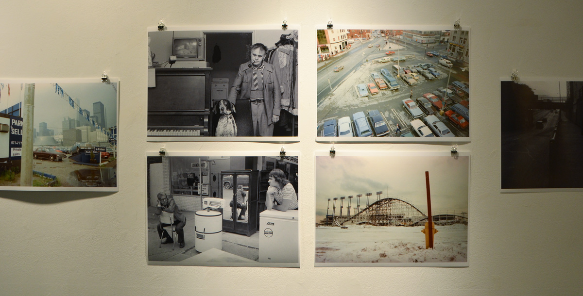
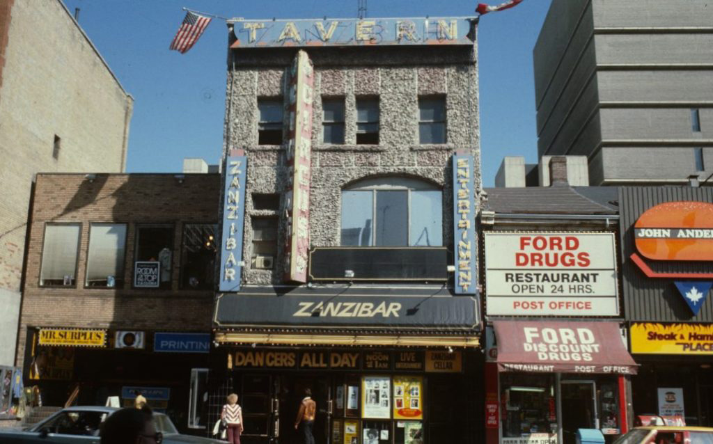
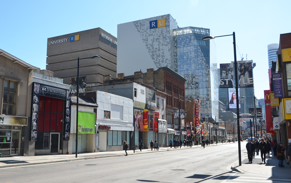
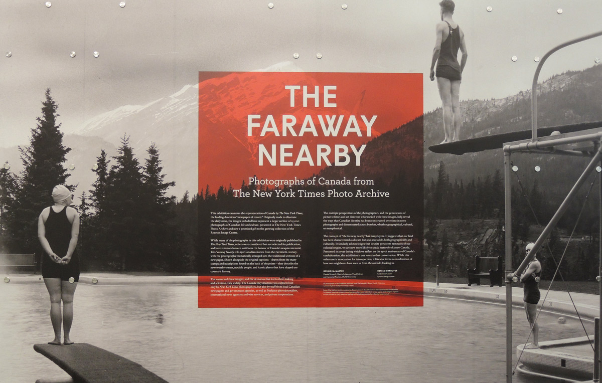
There are a group of photography exhibits now showing at the Ryerson Image Centre.  Two of them showcase older photos of Canada.  The largest exhibit is ‘Faraway Nearby’ and it consists of photographs of Canada from the New York Times photo archive…   25,000 vintage photos of Canada taken over the past 100 years have been gifted to Ryerson by Chris Bratty in honour of his father Rudolph (Rudy), a property developer in the GTA.   ‘Faraway Nearby’ is a wonderful selection of them covering a wide cross section of subjects.

vintage black and white photo of people in bath suits standing on diving boards beside a lake

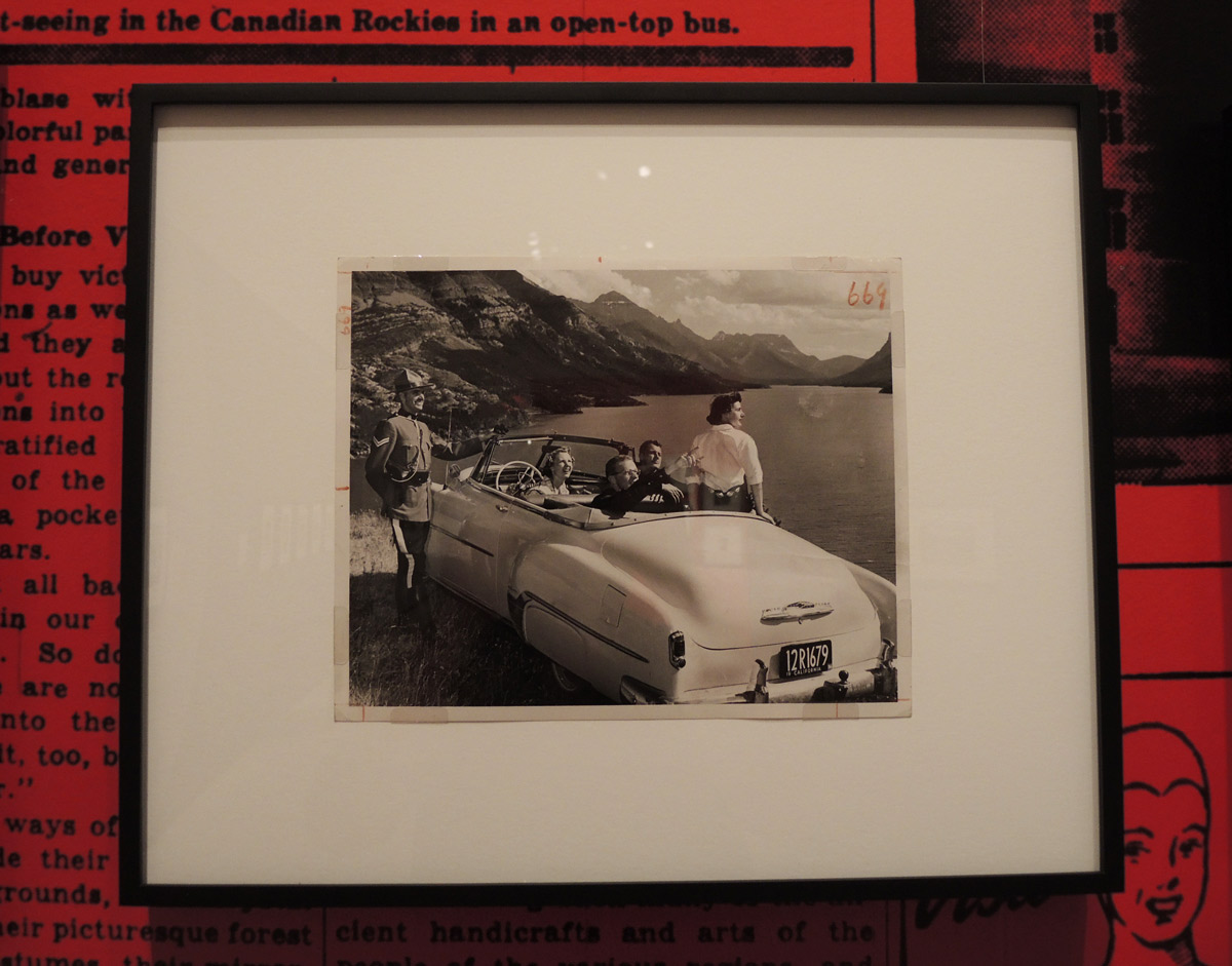
below: There is a section devoted to tourist type photos that you would find in the travel section of a newspaper.  Yes, that’s an RCMP officer standing beside the car, a convertible with California plates.  I’d say it was kitschy to have the RCMP guy there but even today the red uniform of the RCMP is iconic; they are featured on many postcards and souvenirs.   Tourists still take photos with them I’m sure.

photo in an exhibit of a group of tourists in a convertible car with California plates parked beside the road and overlooking a mountain lake. An RCMP officer stands beside the car.

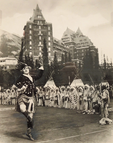
below:  Oh dear, Highland dancers and Native Americans all dressed up.   Is that the Banff Springs Hotel?  The exhibit taken as a whole is a fascinating look at Canadian history; how far we’ve come in some respects and how we haven’t really changed in others.

vintage black and white photo of a highland dancer with a line of native Americans in traditional dress behind her. Some teepees in the background, also a hotel.

below:  Loggers clearing their way through a sea of timber that is being guided into a newsprint mill in Hull Quebec, about 1946.  Unknown photographer.  (Almost all the photos are by ‘unknown’).

vintage black and white photo of two shirtless men on legs with poles as the move logs and timber by river to a newsprint paper mill on the other shore.

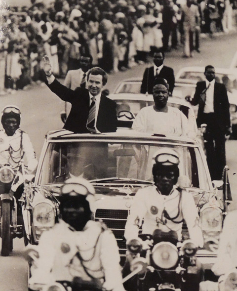
Being a newspaper, a large number of the subjects were political such as this photo of Joe Clark, Prime Minister of Canada from June 1979 to March 1980, on a visit to Cameroon  in the summer of 1979.

black and white photo from 1979 of Joe Clark, then Prime Minister of Canada, riding in a motorcade with the President of Cameroon, in Cameroon.

below: Prime Minister Trudeau (the first one) meeting President Nixon, “Tricky Dick”, of the USA.  Love the sunglasses! (or is that just a trick of the lighting?).

vintage photo of Richard Nixon, President of the United States, greeting Pierre Elliott Trudeau, Prime Minister of Canada

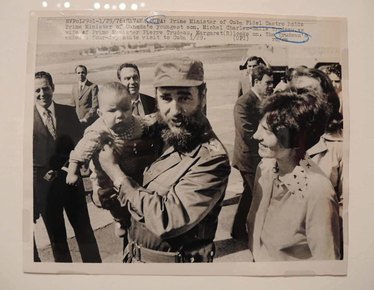
below: While on the topic of the Trudeau’s, here’s Margaret with Fidel Castro.  Castro is holding Margaret’s youngest son Michel.  The photo was taken in Havana in 1976 when the Trudeau’s were in Cuba on a 4 day state visit.

vintage black and white photo of Margaret Trudeau and Fidel Castro. Castro is holding one of the Trudeau sons.

below: There are also some photos taken during various Royal visits.  Here are a group of men by Lake Nipigon in 1919.  The man holding the dead duck (3rd from the left) is Edward, Prince of Wales (b.1894 – d.1972).   He was 25 years old in this picture.   On 20 January 1936 he became King Edward VIII but he abdicated the throne in December of the same year after reigning for only 326 days.

a vintage black and white photo of a group of men in northern Ontario, by a lake, one is holding a duck that has been shot

below: A photo by an unknown photographer for the Canadian War Records Office and the American Press Association, Vimy, France, April 1917.  The description of the photo reads: “Giving Fritz some of his own pills.  Canadians firing a German 4.2 on the retreating Boche.  Some of the guns left behind by the retreating Germans were in excellent condition, and the Canadians at once  undertook to return some of the shells to their former owners in the most effective manner.”

vintage world war one photo

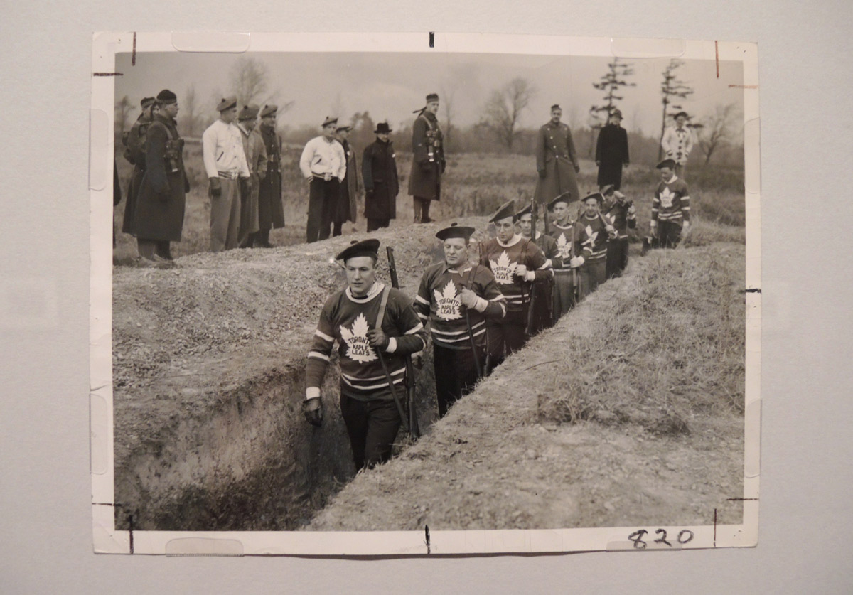
below: A slightly lighter look at war, this time WW2.  Photograph by Nat Turofsky (d. 1956) for Alexandra Studio.  Distributed by the Star Newspaper Service and the New York Times.  Location unknown. 1939.  Nat and his brother Lou were well known Toronto photographers in their day. Back in 2009, The Torontoist published an excellent story about them and the Alexandra Studio which they owned.

The description of the photo reads: “Shouldering guns instead of hockey sticks.  Member of the Toronto Maple Leaf hockey team, led by Bob Davidson, Goalie “Turk” Broda, and “Sweeney Shriner, marching into the trenches at a machine gun target range during a military training session.  The team is in constant training so that they will be ready for duty if called to the colors.”

vintage photo of men in Maple Leafs hockey sweaters walking through war trenches

***

The second, and smaller, exhibit is ‘The Notman Studio:  1858-1915’.  William Notman was a photographer based in Montreal who traveled across Canada documenting what he saw.   He was also a studio photographer who took hundreds of portraits.   This is a small sample of his work.

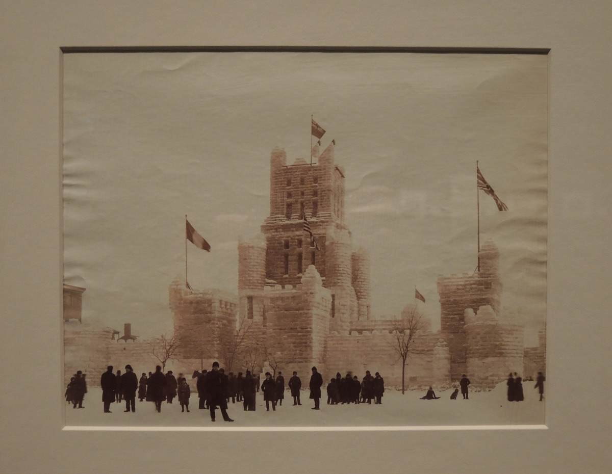
below:  ‘Ice Castle’ about 1857, Montreal Quebec, Albumen print.

old photo of a large ice castle

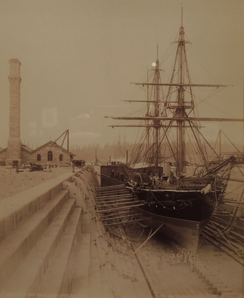
below: ‘Esquimalt Dry Dock’, 1887, Victoria B.C. Albumen print.   You’ll have to pardon the reflections in the pictures.  The glass in the frames acts like a mirror and although I have tried to minimize the amount of reflection, getting rid of it entirely was not always possible.

vintage photo, 1887 ship being built, wood, in Victoria B.C.

below: Standing outside his teepee with his rifle and his horse.

vintage photo of a native American man in traditional clothes holding a rifle and a horse and a lead. Standing outside a teepee

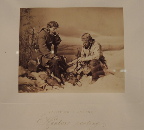
below: There were a series of Cariboo Hunting photos.  They were small and all focused on the two men.   Especially considering their age, they are in excellent condition and beautiful to look at.

vintage photo of two men hunting caribou. Resting with their rifles.

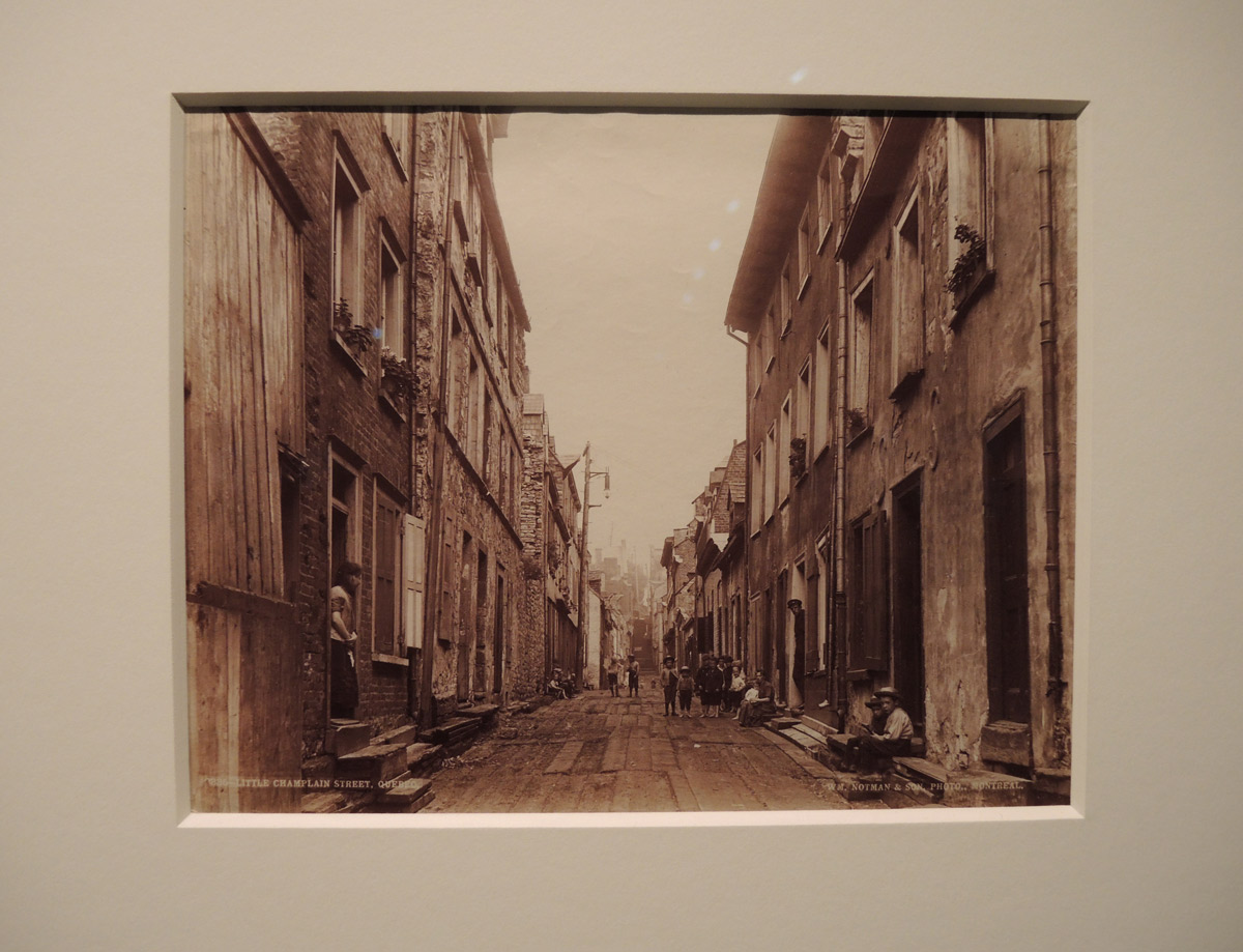
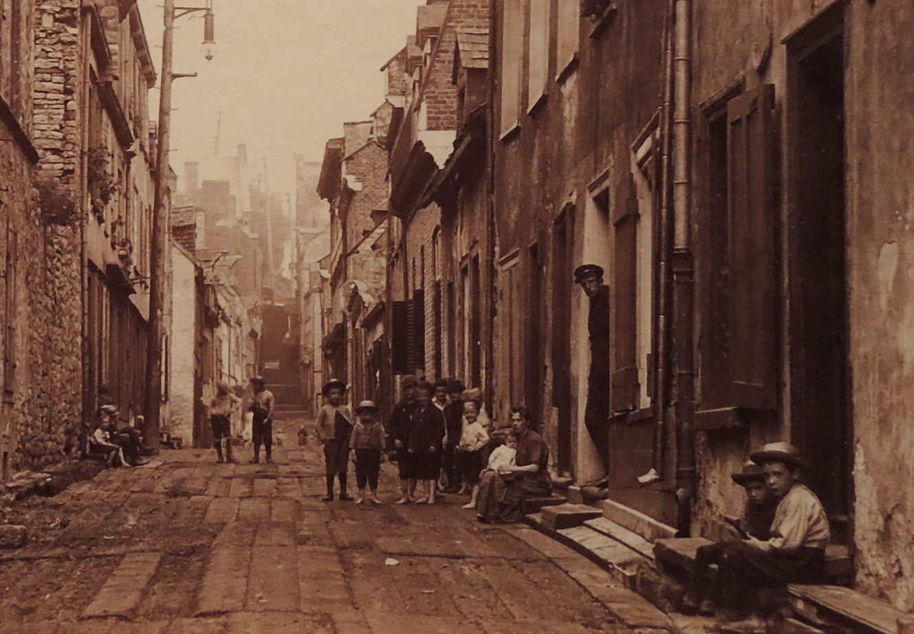
below: ‘Little Champlain Street’  1890, Quebec City.   I looked for photos of Toronto in the collection that was on display but there weren’t any.

vintage albumen print photo, 1890, Little Champlain street in Quebec City. row houses, kids in the street

below: There is an incredible amount of detail in the above picture so I cropped it quite a bit to highlight some of the details.   The shabby brick and plaster row houses, the solitary street light, the planks that form the narrow road, and the kids wearing hats as they keep an eye on the photographer.  Although it is Quebec City, I can imagine parts of Toronto looking quite similar at the time.

details of a vintage photo, street scene, kids, row houses,

In case you were wondering, albumen prints refers to a process whereby the photographic paper that is used to print the images from a negative was made using egg whites.  The main constituent of egg whites is the protein albumen.  It is sticky and forms a glossy finish when it dries.  The stickiness of the albumen is used to bind salt (sodium chloride, your basic table salt, or ammonium chloride) to the paper.  Once the paper dries, it is dipped into a solution of silver nitrate thereby making the paper sensitive to UV light.   This method was developed in 1847 and was the first commercially viable method of producing photographic paper.  It remained in use until the 20th century.

By the entrance to the Notman exhibit is this wonderful, and still relevant, quote attributed to William Notman: “To consider Photography a mere mechanical art, is a great mistake.  The too prevalent desire for cheapness, and the ease with which a little may be done in Photography, has induced many to embrace the profession lacking the necessary qualifications…”

Both exhibits continue until 10 Dec 2017.