Archive for the ‘public art’ Category

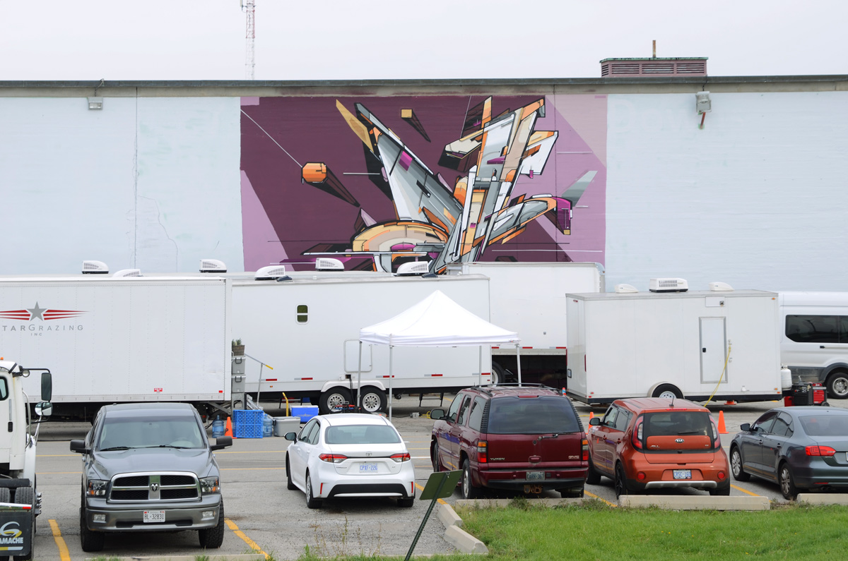
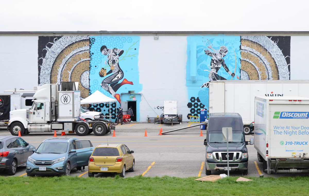
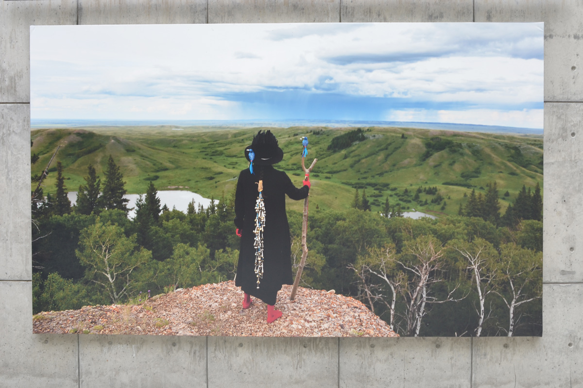
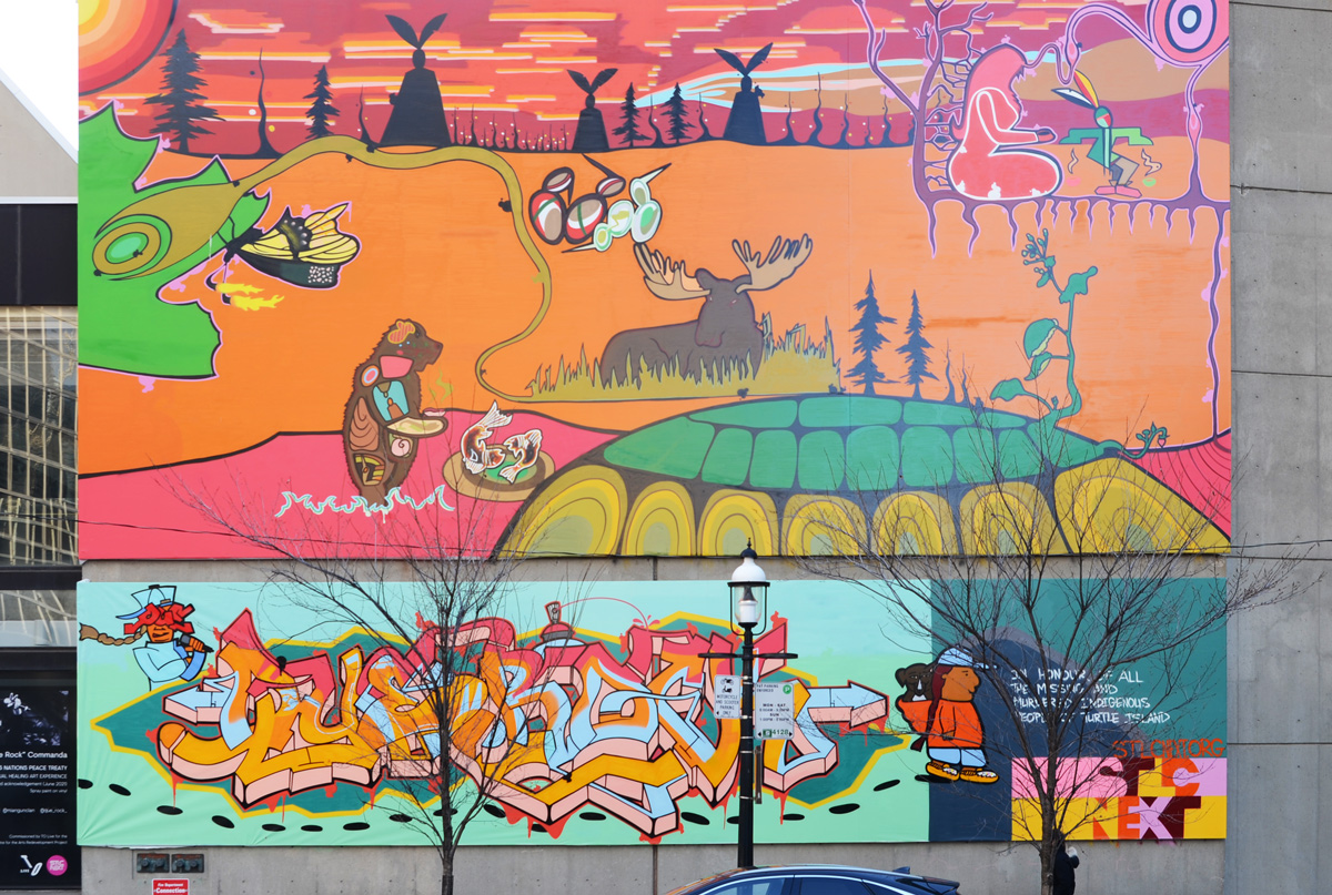
There is a large mural (40′ x 50′) in downtown Toronto on the west wall of the St. Lawrence Centre for the Arts on Front Street East. It was painted by Quentin Commanda, aka Que Rock.

large mural with First Nations themes, painted by Quentin Commanda, outdoor scene, butterfly, bear in pink water, fish, turtle island, moose, orange grass, sunset or sunrise sky, woman sitting,

below: Commanda’s “Artist Statement” – see below the picture to read the transcription.

on a wall beside a mural, words that are the artist statement for the mural, also a picture of the artist, Quentin Commanda,

Artist Statement:

This mural is meant to be a visual healing experience. The seven rings around Grandfather Sun represent the seven Grandfather teachings of the Anishinaabe people: Wisdom, Love, Humility, Respect, Honesty, Courage, and Truth. There are many layers of sacred geometry patterns on the mural.

The skyline includes the medicine-wheel teachings, Grandmother Moon and the 13 grandmother clan systems. The turtle shell represents North America’s creation story, the 13 full moons per year, and the seven grandfather teachings.

The entire mural also represents the original Peace Treaty of the Six Nations on Turtle Island (North America). The story of the Six Nations Treaty starts with the original five Nations of Turtle Island: the Plant Nation, the Insect Nation, the Bird Nation, the Fish Nation, and the Animal Nation. All five Nations had to agree to let the Human Nation live here on Mother Earth. All five Nations agreed to be humanity’s teachers and the Human Nation was invited to share the land.

The Human Nation was given instructions on how to live on Mother Earth, walk gentle on Mother Earth, learn one new thing every day, and share with one another. These are some of the original instructions given to the Anishinaabe people. The bear represents a Medicine Clan. The Mukwa (bear) is a healer, it is the only animal who communicates with all Six Nations.

The bottom panel represents my story from the past, present, and future. The first character with the microphone is the future and present me. The second character represents my past as a native child with my dog Miangun and the path of healing I have taken to decolonize myself back to the Anishinaabe child I was born to be.

My mother is a residential school survivor and so was my father. I am no different than the 215 children found in Kamloops, B.C. I survived to tell you this story and share my experiences. My community is still here and so am I.

The Artist is from Nbiising or Nipissing First Nation, his traditional name is Manitou Nemeen (Spirit Dancing) and he is from the Miangun Dodem (Wolf Clan).

The orange background on the mural represents the missing/murdered Indigenous peoples of Turtle Island.

The mural was commissioned by TO Live

man with dog, people sitting inrestaurants, window reflections, man walking out of restaurant, street scene

below: Leslieville mural on the west wall of Dave’s Hot Chicken, Queen Street East location.

Leslieville mural on the west side of Dave's Hot Chicken restaurant

below: I spotted a very similar piece of paper downtown but with words about knowledge and ignorance (see previous blog post). I wonder how many of these are tacked up around the city?  These words can be attributed to American economist and social theorist, Thomas Sowell (b. 1930).

stapled to a notice board on the sidewalk is text graffiti with words about responsibility

“We seem to be getting closer and closer to a situation where nobody’s responsible for what they did but we are all responsible for what somebody else did.”


below: Beside Jimmy Simpson Park there are four stainless steel pennants, each with a word – coursing, disappearing, trembling, and returning.  These are part of a series of three installations called “Time and a Clock” by Eldon Garnet in the area.

people walking on sidewalk, walking past 4 metal poles holding up words in metal

below: Jumblefacefoto collage paste-ups.

large jumblefacefoto collage paste up on a wall on Queen Street East, 3 vertical panels

below: Boston Discount Store with it’s red and white KitKat advert

Boston Discount Store with its red and white kit kat advert on sign, on Queen Street East

below: posters and protests and one very muscular man three times.

posters on a metal utility pole

below: Queen and Jones Pawnbrokers

Pawkbrokers shop on Queen East, metal grille covering windows, people walking past,

below: Eddie’s Convenience with a range of tests available.  I first read it as though Eddie was also selling pregnancy tests!

signs in the window of a convenience store, covid test, pregnancy tests, in home self test,

below: It’s now been 2 years since COVID was declared a pandemic.

a window full of covid masks on sale on display at a convenience store

below: Queen East mishmash of rooflines. Newer boxy construction butting up against older original half gables with their gingerbread still intact.

a row of stores on the south side of Queen East, with different rooflines after various alterations over the years

below: In a lovely older brick building with little architectural details, Fortune Smoke & Gifts Store along with Butchers of Distinction

In a lovely older brick building, Fortune Smoke & Gifts Store along with Butchers of Distinction

below: Busy Street runs parallel to Queen, one block north. It was once a very busy street.

beside some large trees, a Toronto blue and white street sign for Busy Street

But now it is much quieter. Some of the buildings on the north side were once stables for the teams of draft horses that delivered the goods from the nearby Queen Street stores.

street scene, a woman by her car, some houses, Busy street is one block long,

below: The horses have long disappeared and the buildings have been repurposed.

entrance to thunder thighs costume ltd, with green awning over brown double doors.

intersection on Queen East with billboard, mural, traffic lights, sidewalk, pedestrians,

below: Another little upper storey addition above Cask Music and Samaira’s.

cask music store and samaira's on queen east, with a small recently added upper level, people on the sidewalk in front of the stores,

below: Moving up in an alley

prefab white metal structure as upper storeys on older brick building, with exterior stairs to the alley

below: Ubiquitous

construction fence leaning outward, posters, porta potty, construction site

below: Feelings boi graffiti paste-up

feelings boi sticker on the side of a parking meter

small graffiti on a white concrete wall, blue lips, dark blue sunglasses stencil,

It seems like it’s been a long winter with more extended periods of colder temperatures as well as never ending snow.  Last weekend was the first sign that maybe spring would arrive this year …. before the snow came back!  Here are a few things that I saw on my walk last Sunday while out enjoying some warm sunshine.

below: A sign of the times; a sign for the coming spring.

wood letters on wood fence that say Outside We Will Live Again

CN Tower with Gardiner Expressway in front, signs for exit for Bay, York, and Yonge streets,

below:  There is still a large parking lot on the corner of Rees and Queens Quay.  It may be the last piece of undeveloped property along this part of the waterfront.

parking booth at parking lot on northwest corner of Rees and Queens Quay, tall condos and aprtments in the background, also the Gardiner Expressway

below: Clearing away the piles of snow.

a front end loader removes snow from the waterfront, with the Empire Sandy, boat, parked right beside

below: The skating rink beside the Power Plant is melting quickly.  The designs painted on the concrete below provide a bright contrast to the towers of glass and steel nearby.

ice melting on skating rink by power plant, pink and blue designs painted on the concrete below, highrises in the background, looking northeast from walkway by waterfront

below: Same spot as above but this time looking northwest.

melting ice on the skating rink, looking northwest

below: On the south wall of The Power Plant, a large image of the artist, Sasha Huber, on top of a Swiss mountain.

large picture on the outside, south, wall of the The Power Plant. A picture of the artist, Sasha Huber, planting a sign and plaque for Rentyhorn, renaming a Swiss mountain.

“Rentyhorn” (2008) is part of a campaign to rename Agassizhorn, a Swiss mountain peak. Louis Agassiz (1807-1873) was a Swiss glaciologist who became convinced that Blacks were an inferior species and that he could prove it. Renty was an enslaved woman who was one of a group forcibly photographed by Agassiz in his attempt to prove his theory. There is more of this story, and more of Huber’s work, on display in the gallery.

below: Reflections and distortions in the windows of The Power Plant.

reflections of Canada Square in the glass of the north wall of the Power PLant

below: Queens Quay

cyclists ride by on Queens Quay, past a box on the sidewalk painted in an abstract design

below: “Compartment Earth” in the lobby of RBC WaterPark Place building on Queens Quay.   It is 16,000 pounds of stainless steel; a sculpture by American artist Roxy Paine.

large metal spherical shaped sculpture in the glass surrounded lobby of rbc waterpark building on Queens Quay

below: Work continues on the park, Love Park, that replaces the old York Street exit ramp from the Gardiner Expressway.

waiting to cross Queens Quay at York, by black hoardings around redevelopment of Love Park,

large letters, L O V E spell love on black haordings, letters are decorated in abstract patterns in pink, yellow, and blue

below: Esmaa Mohamoud‘s large image titled: ” The Brotherhood FUBU (For Us, By Us)” covers 37 x 144 feet (or 11 x 44 metres).

a very large photo of two men high on a wall overlooking the street, Bay street, a group of three people with luggage is walking by

below: Looking up to the blue sky.

reflections and angles on large tall gkass buildings, lots of sky and cloud reflections

below: Part art, part health, this is “Visoleil” in the lobby of the new CIBC Square.  A glowing circle of light to lift the spirits during the grey of a Toronto winter.   I went on a Sunday and the doors were locked so I couldn’t get closer.  Unfortunately, it’s probably gone by now as it was scheduled to be removed on 11th March.

large round white light, lit, inside the entrance of an office building, behind glass, art exhibit, Glowing Orb

below: Also at CIBC Square, “Light Stolen from the Sun” by Steve Driscoll.   This new CIBC building on (by the new GO Station and across from Union Station) has been under construction for a few years now.  It isn’t quite finished.

behind construction fence, coloured glass ready to install inside a new office building

below: Looking through the front window you can catch a glimpse of this magnificent piece of backlit glass.  Apparently there are twelve.  This is something that I am definitely going to come back to see!

looking in the window of the new CIBC building in downtown Toronto, interior glass windows, very tall, of a scene with red leaves on tree and blue sky,

below: Street closed.  Construction.

Lower Simcoe street closed to traffic because of construction

below: More construction, King and John.

a man walks across intersection of John and King, with construction

below: Development notice on Crocodile Rock… yikes, 68 storeys proposed at Adelaide and Duncan.

blue and white city of toronto development notice on wall of Crocodile Rock

below: Northeast corner of Adelaide and Duncan

northeast corner of intersection of Adelaide and Duncan with Crocodile Rock bar on the corner

below: Hoardings on Lower Simcoe street – “A Stroll Through the City” by Camilla Teodoro

pictures painted on hoardings around building

below: Looking west on Front Street from Bay with Union Station, CN Tower, Royal Bank building, and the Royal York Hotel.

Front Street in front of Union station

below: In Simcoe Park (Front Street), there is an aluminium sculpture by British artist Anish Kapoor.  It was installed in 1995.

public art, mountains, amid the trees (real) in Simcoe Park

below: Outside Metro Hall, a banner promoting COVID-19 vaccination in kids.

city of Toronto banner promoting vaccination of kids against covid

below: Snarky graffiti – “It takes considerable knowledge just to realize the extent of your own ignorance.”

text graffiti on white paper pasteup

below: Signs on traffic construction cones

beside construction equipment, orange and black traffic cone with yellow poster that says At what cost?

on the sidewalk by a construction sign,orange and black traffic cone with yellow poster that says You're Not Alone

by painted curb between road and bike lane, orange and black traffic cone with yellow poster that asks Two Weeks?

below: Protest posters and graffiti. Anti condo development & corrupt landlords. Mercury contamination of water.

graffiti and posters on the side of a red metal newspaper box on the sidewalk. I'm feeling blue sticker, and an anti development poster saying greed is bad

posters and graffiti on a metal box

pasteup graffiti on metal box on sidewalk, eyes, text,

…at the Forks of the Don

If you’ve driven on the Don Valley Parkway you’ve probably seen them, the big grey structures that look like teeth.  They are just south of Don Mills Road, on both sides of the DVP.  Over the years, the trees and shrubs have been growing around them so they don’t stand out as much as they did when they were first installed in 1998.

below: On the west side of the Parkway

an old and rusted city street sign, maximum 30 km/h begins, with elevated wetlands sculptures behind

The structures were designed by Noel Harding (1945-2016) and are constructed out of recycled polystyrene and acrylic. Financing was provided by a group from the Canadian Plastics Industry Association.

large concrete containers, planters, on a small hill with small trees, winter,

Their purpose is to help purify polluted water from the Don River watershed.

below: On the west side, the third planter stands alone, looking a bit like the back end of an elephant.

large grey planter for wetlands water purification, looks like the back end of an elephant, with four stumpy legs

large container on right with spout to concrete planter on the left, in the background, seen between the two concrete planters, an old cement bridge and a highrise apartment in the distance

below: The three concrete structures form a line on the east side of the DVP.

looking across traffic on the Don Valley Parkway to the other set of elevated wetlands sculptures

They can be accessed by following the trail that goes under the highway and follows Taylor Massey Creek.  If you follow this route, you end up walking generally east and you can walk for miles through the ravine system that runs under O’Connor Drive, through Taylor Creek Park and on to Warden Woods Park.

roadway curves to the right and passes under the Don Valley Parkway, traffic crossing over the bridge, winter time, snow on the ground, Forks of the Don where Taylor Massey Creek joins the Don River

Forks of the Don – where rivers come together, trails go in all directions, and even the railway passes through.

below: Stairs up to Don Mills Road and Gateway Blvd,

stairs leading up, to an apartment building, trees, winter

below: Or take the ramp that passes under Don Mills Road beside the tracks.

blue sign on a concrete pillar that says Don Mills Road, beside a metal ramp walkway under a bridge, Lower Don Trail

below: Looking southbound towards Union Station.

vehicle on train tracks approaching an underpass, where Don Mills Road crosses the tracks

below: From here the tracks follow the Don Valley east and then north.  They pass under Don Mills Road once more, just south of York Mills Road, before heading to Oriole GO station.

looking through gaps in a chainlink fence, a railway vehicle on the tracks below, looking eastward from Don Mills Road, apartment buildings in the background

below: This part of the Lower Don Trail really is a nexus, or hub, in the ravine path system.  Trails also lead northwest to the Science Center and Wilket Creek Park.

three people walking across a snow covered park towards highrise buildings

below: Choose kindness

colorful sticker on metal railing, lots of one eyed faces with big teeth on the back of a van with words choose kindness

heart painted on metal rail, graffiti, left side is red and right side is blue

a car drives over an old semi circular concrete bridge over the Don River, Gateway Blvd apartment building in the background

road bridge, concrete, above a river with a parth beside the river. Rusted metal railings on both sides of the path, green metal beams under the bridge, winter, sone snow, no leaves on the trees, Lower Don Trail, under Don Mills Road

below: “Passage”, an art installation by Labspace Studio under the Don Mills Bridge – part of the PanAm Path project.

public art under a bridge, halves of red canoes appear to come out of the wall, 8 of them in a line

below: Southward on the Lower Don Trail where you can walk all the way to Lake Ontario.

lower don trail, looking south, with DVP on one side and trees on the other, apartment building in the background.

below: If you are interested, this is a map of the PanAm Path, one of the projects from when the PanAm games were hosted here in Toronto in 2015.  The Forks of the Don is in the center by the pink X.  Something to consider exploring in the spring!?

city of Toronto map of the PanAm Path that crosses the city.

*****
plaque describing the elevated wetlands sculptures

“The elevated wetlands are functional sculptures, symbols of the integration of the plastics industry, art and environmental stewardship. The sculptures were developed through a partnership between the City of Toronto, the Canadian Plastics Industry Association, and artist Noel Harding.”

“The sculptures draw attention to the importance of wetlands as an ecosystem. A solar powered pump lifts water from the Don River into a series of raised “planters” where native wetland plants and trees naturally remove pollutants from the water. Recycled plastics are used as soil substitute to promote vegetative growth. From the smallest container, water is emptied into a natural land based wetland, and flows back in to the Don River. The surrounding area has been naturalized through volunteer tree plantings to create a natural buffer between the sculptures and the Don Valley Parkway. “


a small pink knitted heart is tied to the branch of a small tree

Winter Stations 2022

a sign by path at beach that says don't feed the foxes

From late February through to the end of March is Winter Stations on Woodbine Beach along Toronto’s waterfront.

Toronto waterfront, by Ashbridge Bay, Lake Ontario, winter stations 2022, people and dogs on the beach with a few art installations

below: “The Hive” by Canadians, Kathleen Dogantzis & Will Cuthbert

Hive, at winter stations 2022,

looking through the coloured plexiglass panels of Hive, an art installation on Woodbine Beach

below: Designed by a team from Daniels Faculty of Architecture, U of T, “Introspection”.

Introspection, art installation at Woodbine Beach designed by University of Toronto John H. Daniels Faculty of Architecture, Landscape and Design team of – Christopher Hardy, Tomasz Weinberger, Clement Sung, Jason Wu, Jacob Henriquez, Christopher Law, Anthony Mattacchione, George Wang, Maggie MacPhie & Zoey Chao, Lead by Assistant Professor – Teaching Stream Fiona Lim Tung

part of "Introspection" an art installation, red box on the waterfront with reflective insides

inside Introspection , reflecrive surface, art installation

below: Designed by a Turkish pair, Cemre Önertürk and Ege Çakır is “Enter-Face”.

two Muskoka chairs sit in the ice at Woodbine Beach, with art installation Enter-Face behind them

below: The structure on the left has circular openings on one side and a translucent panel on the other (lakeside) – you can through but the resulting view is slightly distorted. On the taller structure, there is a reflective material.

on Woodbine Beach, an art installation called Enter-Face by Turkish design team, MELT, Cemre Önertürk & Ege Çakır

view from outside of Enter Face, an art installation at winter stations

below: “S’winter Station” was designed by a team from Ryerson University’s Department of Architectural Science.  The circular openings on the surface panels were made from beach towels, an object more associated with summer than with winter.

a woman with blue paper? beside art installation designed by Evan Fernandes, Kelvin Hoang, Alexandra Winslow, Justin Lieberman & Ariel Weiss, Lead by Associate Professor Vincent Hui from Ryerson

a woman and a dog on the beach, under the overhang of an art installation, S'winter station,

below: “One Canada” by a team from School of Environmental Design and Rural Development at the University of Guelph.  The “One” in the title is for the combining of Indigenous and Non-Indigenous together as one.  Seven rings representing wisdom, love, respect, bravery, honesty, humility, and truth.  Orange (for National Day of Truth and Reconciliation) ropes weave the rings together in a pattern echoing those used to make drums.

on the waterfront, beach, with lake behind, an art installation.

part of One Canada installation at Winter Stations, close up of orange cords that form the frame, people and dogs and beach in the background. Design team: Alex Feenstra, Megan Haralovich, Zhengyang Hua, Noah Tran, Haley White & Connor Winrow, Lead by Assistant Professor Afshin Ashari and Associate Professor Sean Kelly

In 1913, businessman Miller Lash bought a piece of land at what is now Old Kingston Road and Morningside Avenue where the Highland Creek flows. He built a house for his family by the creek and a coach house for his collection of cars nearby. They were made of poured concrete faced with river rocks that had been collected from the creek. The two buildings remain on they site but now they are owned by the University of Toronto Scarborough campus and have been repurposed.

below: Lace curtain in a window of the Miller Lash house.

window with lace curtain from the outside. building is made of river rock and is covered with vines with purple berries

The University of Toronto acquired the land in the 1960s. Toronto architect John Andrews designed the initial two buildings, the Humanities Wing and the Science Wing, which opened for students in January 1966.  Both were built at the top of the ravine.

Last week when I walked around the campus it was very quiet; very few students were present.  Most of the people I saw were like me, taking pictures of the buildings, or they were out for a walk through the woods. In class learning for UTSC’s almost 13,000 students resumes tomorrow, February 7th.

benches covered in snow, in front of brown tall grasses and a shiny facade of a building

below: “Tall Couple” (or “Un Grand Couple”) by Louis Archambault (1915-2003) stands beside one of Andrew’s buildings, the Humanities Wing. This metal sculpture was first on display at Expo ’67 in Montreal.

The Tall Couple, or Un Grand Couple, a metal sculpture by Louis Archambault on the campus of Scarborough College (U of T), in the snow

The newest building on the campus is Highland Hall located by the main entrance to the campus on Military Trail. It features large pillars, red accents, and a glass facade.

below: The west side, main entrance side, above the pillars is a large glass feature that shows a satellite image of Scarborough.

a couple taking photos at utsc, including Highland Hall west side, new building, large amounts of glass with reflections as well

below: East side of Highland Hall. The upper level on this side features an aerial image of Scarborough in the mid 1960s when the college first opened.

the east side of Highland Hall, a new building on the Scarborough campus of University of Toronto, with a large glass facade on the upper level.

a chair and desk inside a building but facing out, close to the window

below: From CONTACT Photography 2021 (on view until March 2022), is “I’m Listening” by Ebti Nabag.

more than lifesized black and white pictures of two women on exterior concrete wall

below: From the Solar Walk around the campus, information about Mars.

from the solar walk at utsc, Mars, a picture of the planet plus a plaque with information about mars

below: … and also Neptune. The Solar Walk was supported by the Canada 150 Fund that celebrated Canada’s 150th anniversary of Confederation. The position of the planets on the walk represent to position that they were in on 1 July 1867.

plaque with picture and information about the planet neptune on a solar walk on the scarborough campus of the university of toronto.

below: The Highland Creek still runs through the campus. There is a new walkway that winds its way down the side of the ravine from the main part of campus to the tennis courts, athletic fields, creek trails, and park.  Here the new path curves in front of the Science Wing.

curved walkway down the side of a ravine beside Scarborough campus concrete buildings built in the 1960s, winter

below: Signs of human activity beside the trail.

a group of three tree trunks with initials and other symbols cut into the bark, winter

below: Construction crew working on the banks of the Highland Creek.

construction crew reinforcing the banks of the Highland creek with large rocks, winter,

buildings at U of T Scarborough in the winter

below: Koa Hall, side view

Koa Hall, side view, University of Toronto Scarborough campus, in winter, with tall trees

utsc buildings including home of The Underground, the student newspaper

bike parked, almost totally covered by a snow bank

below: The modern equivalent of the smoking lounge?

a man wearing parka and toque sits outside smoking, sitting on a chair in a small clearing in the snow

Find your uncharted territory and explore!

below: Unchartered

banner on light standard at University of Toronto Scarbourgh Campus that says the uncharted is an invitation to explore


mural, blue letters on yellow, XOXO Downsview

below: Ulysses Curtis mural by Danilo Deluxo McCallum.  Curtis (1926-2013) played for the Toronto Argonauts football team in the 1950s.  He was considered to be the first black player on the team.

mural, black man with helmet and shoulder harness straps

The Downsview area and airplanes have been linked since the late 1920s when land here was being used for airfields—Barker Field, the Canadian Express Airport and the Toronto Flying Club.  In 1929 de Havilland Aircraft of Canada purchased 70 acres of farmland along Sheppard Avenue West.  In the mid-1950s de Havilland moved its operations to newly constructed modern facilities to the southeast.  De Havilland Canada was sold to Boeing in 1988 and then to Bombardier in 1992.

below: Bombardier facility and GO tracks on the east side of the park.   Downsview Park station at the north end of the park connects the GO system with the TTC’s Line 1.

Bombardier facility beside GO tracks in Downsview

In 2017, the Sesquicentennial Trail was developed on part of the site.  Sesquicentennial means 150 years, as in Canada was 150 years old in 2017.

below: The North Plaza of the trail features a semi-circular wall of rusted steel with cutout silhouettes of real historical photographs showing various people, buildings, and airplanes that was designed by John Dickson.

rusted metal art installation with sections of wall with cutout pictures, airplane windsock in front

part of an art installation, rusted metal with cut out pictures, cut out words that say danger low flying aircraft stop until clear

two pictures cutout of rusted metal

Small models of four of the aircraft built by DeHaviland ‘fly’ over the trail – the DH.60 Gipsy Moth, the Dash 8, the DHC-6 Twin Otter, and the Mosquito.   They cover years of both DeHaviland and aircraft history from the bi-winged Moth in the mid-1920’s to the turboprop Dash8. The later was developed in the early 1980s and is still in production today.

plaque describing 4 of the types of aircraft once produced in Downsview, DH.60 Gipsy Moth, the Dash 8, the DHC-6 Twin Otter, and the Mosquito

two model airplanes on pillars, look like they are flying above a pond, park, and new apartments under construction

below: High overhead, a DHC-Beaver, a bush plane developed in 1947 here at Downsview.

large metal flat silhouette of beaver airplane on tall metal poles as public art in a park

Grounded! But still great for child’s play.

playground at Downsview Park, yellow wood airplane on ground with pretend control tower

Hundreds, and probably thousands, of trees have been planted on the site.

two red muskoka chairs near the top of a hill, overlooking the trees in the valley below

below: Tulip tree

autumn colours on a tulip tree

below: Other areas have been set aside for native grasses and wildflowers such as milkweed, purple coneflower, and wild lupine.

plaque at donswview park describing tallgrass prairie and three of the plants that grow there

below: There is a large hill in the park and this is the view to the southwest from there.

Downsview view from hill in the park, looking southwest over a path, some apartment buildings, and rest of Toronto skyline

below: At the top of the hill stands an installation of blue flags along with two of the many red muskoka chairs scattered around the park.   This is “Wind Rose” by Future Simple Studio. This picture doesn’t show it very well but at the northwest corner, two of the flags are not blue – one is black and the other white (black for west and white for north).  These two flags, “The Turtle and the Traveller,” were designed by Mi’kmaq artists Chris and Greg Mitchell.   They are best seen when the wind is blowing!

blue flags hanging from poles, art installation at Downsview Park

maple leaves in autumn

small bird feeder on a tree, with a blue roof with red flower painted on the roof

Downsview has also been associated with the military.  In 1937, the Royal Canadian Air Forces expropriated portions of the site to establish the RCAF Station Downsview.  The site once had two residential areas with barracks – one for the enlisted soldiers and their families and another for the commissioned officers and their families.  Over the years the base expanded to include the original de Havilland lands.  In the 1960s, the military expropriated the lands adjacent to the Downsview Airport and closed 2.5 miles of Sheppard Avenue between Dufferin and Keele Streets.  That is why Sheppard Avenue swings north around what is now Downsview Park.

two small bird houses hanging against a tree, white round one with red conical shaped roof

In 1996 CFB Toronto officially closed.  Parc Downsview Park Inc. was established in 1999 to build and operate Downsview Park but administrative control over the land wasn’t transferred to the Park until 2006.

very red crimson maple leaves in fall

below: ArtworxTO Hub North with a mural by Mediah.  At the time, the site was being used by a film crew.

mediah mural at arthub at Downsview park

below: Another mural on the exterior of the ArtworxTO Hub building.  This one was painted by Kreecha.

mural at arthub at Downsview park

stickers on the back of a dark coloured car, robots shooting at stick figures, The Empire Doesn't Care about your stick figure family

The results of a walk on what was probably the last warm evening of the year….

people walking on Queens Quay at night

below: In Sir John A. Macdonald Plaza (that’s the space in front of Union Station by Front Street) is an art installation by Masai Ujiri, “Humanity Movement”.  There are 35 words that represent what humanity means to Ujiri – words such as compassion, love, selfless, collective that are repeated as they cover the eight foot high installation.  A light in the center makes the words appear on the sidewalk and on the structures (and people) around it.

Humanity movement art installation in Sir John A Macdonald Plaza in front of Union Station, by Masai Ujiri. metal cylinder with words cut out, a light shines through from the middle and the words show as lights on the sidewalk

well lit Sir John A Macdonald Plaza in front of Union Station, at night, with lit clock, sculpture and an art installation by Masai Ujiri

below: Inside the Great Hall at Union Station is an image titled “House of Baby” that is the result of a collaboration between Camille Turner and Camal Pirbhal.  It is a image of people in the Great Hall that includes portraits of 18 Indigenous and Black people who were enslaved by the Baby family.

a few people standing in front of an image called house of baby, a collage of people who were enslaved by the Baby family all gathered in Union Station

Francois Baby (1768 Detroit – 1852 Windsor Ont) and his brother James (1763 Detroit – 1833 Toronto) were politicians, businessmen and land owners.  Francois stayed in what was then the Western District of Upper Canada (around Windsor).   His biography is long and I’m not going to go into details here but he did have slaves.  James moved to York in 1815 and was part of the establishment – between 1792 and 1830 he held more than 115 appointments or commissions of varying degrees of importance.

In 1793 John Graves Simcoe, then Lieutenant Governor, tried to abolish slavery in Upper Canada but many of the ruling class, including James Baby, were slave owners and outright abolishment failed.  Instead there was a compromise made (how Canadian!) and restrictions were put on slave ownership such that by 1833 there were none left.  A much more complete history of slavery in Upper Canada can be found in an article at Upper Canada History.

close up of part of an image called house of baby, a collage of people who were enslaved by the Baby family all gathered in Union Station

below: On the York Street side of Union Station

York street side of Union station

below: On the PATH system at 25 York Street there is a mural that is 25 metres long (or 100 feet long); it is “Entire City Project” by Michael Awad, 2009.  It is a warped panorama of commuters outside Union Station.

part of a mural by Michael Awad of people moving together, most walking, one man with a bicycle

below: The lights hanging from the ceiling are another art piece.  “Pixel Matrix”, is a large cube of 30,000 individually controllable LED lights on strings, with constantly changing lighting effects.  It was a collaboration between Michael Awad and David Rokeby


interior of 25 York street with 2 art installations, the hanging glass and lights, and a long mural by Michael Awad

detail of Michael Awad Entire City Project mural of people walking in commute

lights shining through exterior glass walls, blue lights on a staircase

below: Making a kraken.  One tentacle can be seen in the foreground.

below: The kraken’s eye is a video that plays on a screen bulging from the container that can barely hold its contents.  Will the kraken escape?  Is Queens Quay safe?

making a Kraken art installation out of a metal container

below: Lights in motion

a man riding a bike at night with blue LED lights all over it. his helmet has lights too

below:  The art installations at 10 York Street look much different at night!

art installation in the lobby of a condo building on York street

below: Lights over the harbour, Queens Quay

bridge over harbour on Queens Quay, at night, with lights and reflections of light in the water

a couple, at night, standing outside on one of the wave decks on Queens Quay

the back of a large boat, at night, one light on the boat, ladder, blue ropes

entrance and exit to a parking structure at night

2 small plastic orange pylons sit on a ledge in a broken window with a green staircase behind inside the building

two men walking in lit passageway, inside, blue wall on left, carrying photo equipment and tripod

There are two public art exhibits now on display at Harbourfront’s Ontario Square.  The first is “Built on Genocide” by by Jay Soule aka CHIPPEWAR which is part of this year’s Luminato Festival ….  “In the mid-19th century, an estimated 30 to 60 million buffalo roamed the prairies, by the late 1880s, fewer than 300 remained. As the buffalo were slaughtered and the prairie ecosystem decimated, Indigenous peoples were robbed of their foods, lands, and cultures. The buffalo genocide became a genocide of the people” (quote source: Luminato website)

below: The centerpiece is a pile of Buffalo skulls.

a large pile of buffalo skulls, art installation, with glass and steel condos rising behind,

below: Surrounding the skulls are posters that highlight and criticize government policies towards First Nations including (Prime Minister) Sir John A. Macdonald and his “Magic Eraser”, i.e. the Indian Act of 1876.

people looking at large posters, part of art installation, built on genocide

below: The poster on the left references the adoption of First Nations children by non-Native families often referred to as the Sixties Scoop because it reached its peak (most adoptions) in the 1960s.  The plight of Indigenous women is the subject of the other poster – the disproportionate number of whom have been murdered or went missing.

2 posters, adoption of mass destruction, and I am a mother sister auntie grandmother, protest signs on indigenous rights and past Canadian history of abuses

a man on a bike and a woman with a large backpack standing in front of posters by Jay Soule on display outside at Harbourfront, Indigenous Rights, history of abuse, protest,

There is also a display of large photographs by Meryl McMaster.

below: What Will I Say to the Sky and the Earth II.

large photograph by Meryl McMaster on display at Canada Square at Harbourfont - woman standing in the snow

below: On the Edge of This Immensity

woman holding a small boat on her shoulders, lake in the background, large photograph by Meryl McMaster on display at Canada Square at Harbourfont

below: As Immense as the Sky

woman with back to camera on a rock ledge overlooking a green landscape large photograph by Meryl McMaster on display at Canada Square at Harbourfont

on King Street West

a line of 7 large photographs as part of a display by Metro Hall on King Street

On display by Metro Hall on King Street West are a dozen large images created by Taiyo Onorato and Nico Krebs.  This installation is part of the Scotiabank CONTACT Photography Festival.

a woman stops to take a picture of a large photo on display on King Street West while a man and his black dog keep walking past the photos

The pair took photographs in the Maldives.  The fragile environment of these small islands (in the Indian Ocean) is exacerbated by the fact that they are barely above sea level.   There are more than 1000 islands that make up the Maldives and 80% are no higher than a meter above sea level.  Most are uninhabited.

people in front of a display of large photos

Onorato and Krebs have manipulated some of the prints with various methods and in doing to “they create quasi-abstract images that inventively describe their perceptions of place. Fusing reality and imagination, their suite of images are powerful fictions that confront undeniable facts. ” (quote source: Scotiabank Contact website).

three large photographs, part of Future Perfect, an installation by Nico Krebs and Taiyo Onorato,

a woman in a mask walks past photo exhibit Future Perfect by Nico Krebs and Taiyo Onorato