Posts Tagged ‘Coronation Park’

This has been a wet spring along the waterfront.  Lake Ontario has been at its highest level in years.   Earlier, I had posted some photos that I took of Woodbine, Kew and Balmy beaches and the high water levels there (blog post, “water logged”).  The other day I visited the beaches and walkways at the other end of the city’s waterfront, from H2O beach to Ontario Place.

below: Flooding at H2O Beach

Toronto waterfront showing flooding at H 2 O park with its Muskoka chairs and yellow umbrellas, lifesaving ring and ladder are no longer at the shore but quite a ways out in the lake

Toronto waterfront showing flooding at H 2 O park with its Muskoka chairs and yellow umbrellas, dark skies in the distance as a storm approaches

Toronto waterfront showing flooding at H 2 O park with its Muskoka chairs and yellow umbrellas

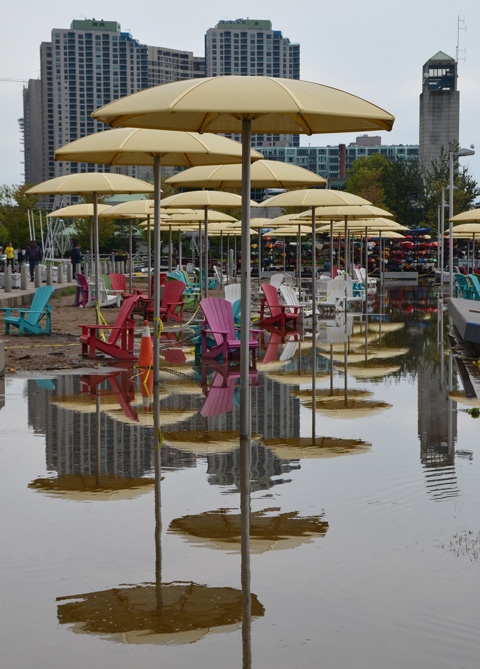
below: All that water makes for some colourful reflections!

Toronto waterfront showing flooding at H 2 O park with its Muskoka chairs and yellow umbrellas, many colourful reflections in the flood waters

below: Looking west towards the old Canada Malting Company silos as the dark clouds signal an approaching storm.

Canada Malting Company old concrete silos on Toronto Waterfront, la large boat docked near the foreground, dark skies over Lake Ontario as a storm approaches

below: The Empire Sandy docked along with the tugboat, M.S. Kane

the Empire Sandy, a three mast sailing ship, docked along side a small tugboat, the M. S. Kane. on a grey wet day

below: Toronto’s fire rescue boat, the William Lyon Mackenzie, docked beside Fire Station 334.   It was built in 1964 and is named for Toronto’s first mayor.

The WIlliam Lyon McKenzie, a bright red fire boat is docked at Toronto waterfront, city skyline behind the boat with tall condos, also dark storm clouds

below: Queens Quay at Spadina, looking west

looking west on Queens Quay at Spadina, streetcar tracks, street, trafiic, pedestrian on sidewalk, TTC street car approaching, Starbucks on the corner, low rise buildings in the background

below: A streetcar starts to head north on Spadina

a new TTC streetcar starts to head north on Spadina, just south of the Gardiner and large condos

below: Playing basketball in the rain.

four boys playing basketball on a green and brown court, in the rain,

below: An old blue canoe at Little Norway park.  A training camp for the Norway’s Air Force was located here (SW corner of  Queens Quay and Bathurst) during WW2.  The large rock that you can see in the photo is a 3000 pound boulder brought from Norway in 1976 to be part of a permanent monument to the people who trained and served here.   In 1986 the space became Little Norway Park.

an old blue canoe is used as a planter in a park

below: Looking back towards downtown and the CN Tower from the western end of Queens Quay West.

looking east along Queens Quay West from the very western end of the ctreet towards the CN Tower and downtown. Lowrise residential units on either side of the street, bike lane, small trees, wet, raining

reflections of sailboats and their masts in Lake Ontario, boats are parked at a yacht club

a lone red Muskoka chair sits on an angle in a small grassy patch between a fence and a path, looks out over a yacht club

below: Lots of big puddles at Coronation Park

flooded pathway, large puddles, along shoreline at Coronation Park, boats in the background

flooded driveway and entrance to underground parking,

below: Yellow flowerpot islands

two large light green flower pots sit on concrete pedestals, in the water, orange cones in the water, shoreline is flooded, some sailboats docked in the background

below: Someone has tied a string of small Canadian flags to the railing at Coronation Park.  Happy Canada Day weekend!

sailboats moored out in Lake Ontario, in the foreground is a metal railing with a string of Canadian flags tied to it

four white sailboats moored in the water, Lake Ontario, with their main sails wrapped up and put away, calm water but grey skies

a large bird sits on a yellow sign out in the waters of Lake Ontario, an orange (or red) light sits on a concrete pedestal beside it

below: Toronto skyline from Trillium Park, from the green trees of Coronation Park on the left and past the CN Tower to Billy Bishop airport on the far left.

In the background is the Toronto skyline from Trillium Park, from the green trees of Coronation Park on the left and past the CN Tower and tall city center buildings, to the National Yacht Club and then Billy Bishop airport on the far left. In the foreground is an orange lifesaving ring and the rocks of the shoreline of the park

below: Large granite rock in Trillium Park

large chunk of granite in a park, black patches with streaks of pink and grey

below: Ontario Place, where TSN was playing to no one.

a large screen plays a TSN show, outdoors, Ontario Place, white chairs but no one is there

below: Flooding by the marina at Ontario Place.  In the foreground is what appears to be an electrical box.

flooding at Ontario Place

flooding at Ontario Place, empty building surrounded by water, boats, cinesphere dome

flooding at Ontario place, orange sandbags and a fence that is partially submerged in the water

scaffolding holds lights for a show at Ontario Place, in the distance is the CN Tower.

below: The Canada geese have these Muskoka chairs to themselves.

By Lake Ontario, a group of white Muskoka chairs in long grass with a lot of Canada Geese standing around them, metal barricades behind chairs and trees behind that

below: From the northwest corner of Ontario Place, looking west over Lake Ontario towards Etobicoke and Mississauga

shoreline of Ontario Place, looking west over Lake Ontario to Etobicoke and Mississauga

on the northwest corner of Ontario Place, gate across path because of flooding, a swan in the water, the wind turbine on the CNE grounds in the distance

elevated buildings of Ontario Place over the water

below: There was also flooding on Lakeshore Blvd.

traffic on Lakeshore Blvd plows through the water and creates great splashes of water, road is partially flooded

a white truck with three men in the cab on Lakeshore Blvd plows through the water and creates great splashes of water, road is partially flooded

below: Puddles in an almost empty parking lot, CNE grounds.

CNE parking lot, empty except for one white car, large puddles with reflections, and the city in the background, CN TOwer, tall buildings,

abstract in blues, made by close up of reflections and ripples in the water

This is another meandering blog post… a post about being out and about on yet another wonderful autumn day, going wherever my feet and eyes take me.

below: The first picture of my day was this intriguing wall made of old wooden doors.  Bathurst Street.

a tall narrow wall about three storeys high made of old white doors.

below: A small elicser mural tucked away at the end of a parking lot.   The man has his back to the viewer but I can’t figure out what’s behind him or what he might be doing.

small mural on a fence, a man's head is back to the viewer

below: The leaves have fallen off the vines to reveal a yellowish creature with his baseball cap askew.

graffiti painting of a yellow animal like creature wearing a blue and yellow baseball cap. The creature is yellow. On a red brick wall, with spots on its back

below: Toronto’s tallest icon framed by a construction crane.

CN Tower in the distance, condo construction in the foreground, with a red crane

below: And on a similar note, a vacant lot cleared and ready for the next stage of its life.

a box beside a fence that has been scrawled over with blue spray paint. Behind it is a fence around a vacant empty lot. There are some small trees growing in front of the fence.

below: No more cranes here (and not many vacant lots either for that matter).  A view showing how much development there has been on the south side of the railway tracks.   Fort York is between the tracks and the condo towers.

a VIA Rail train passes by on one set of many tracks, in the background is Fort York and then a series of new condo buildings.

below: And what’s this? An old blue canoe beached on the tracks?

looking at the scene from a above, a blue canoe has been used to plant plants in. It lies across an old railway track, a chainlink fence separates the canoe from the main railway tracks that still function.

below: Standing guard over Bathurst Street, Fleet street and the Lakeshore, is one larger than life gold replica of a Royal Newfoundland Regiment and his fallen silver American foe. A sculpture by Douglas Copeland entitled “A Monument to the War of 1812”, a nod to nearby Fort York and the history of Toronto.

Douglas Copeland's sculpture of two tin soldiers, a gold one standing with backpack on and rifle in hand, and a silver one lying on its back on the ground, uniforms circa War of 1812, seen from the back, figures are much large than life sized and they are on a corner at an intersection, Bathurst St. and Fleet St.

below: My favorite example of bad grammar still exists!  Off-leash dog area at Coronation Park.

a wood fence around a dog park, in autumn with lots of leaves on the ground, on the fence is a white sign with black letters re the Toronto municipal code 608,

A beautiful day in the park.  A slight November nip was in the air but it was sunny and the sky was a brilliant shade of blue.  Coronation Park is named in honour of the coronation of King George VI who was crowned on 12 May 1937.  At that time nearly 150 trees were planted here.

Apparently, an oak tree was planted to honour the king.  Surrounding it, a ring of silver maples was planted.  This was to symbolize the countries of the British Empire.  I wish I had known that bit of trivia before I walked through the park because now I am curious if these trees are still there.   Some of the trees are quite substantial.

below: Long shadows for the morning sun, low in the sky.

morning in the park, autumn, trees with some leaves still on, many leaves on the ground, wood railing fence, shadows, Lake Ontario, path, Coronation Park.

below: Looking back towards the city center, past the empty docks of the National Yacht Club to the residences on Stadium Road.   A small group of people were making a video in the dog park.

morning in the park, autumn, trees with some leaves still on, many leaves on the ground, wood railing fence, shadows, Lake Ontario, path, Coronation Park. a small group of people in the distance are filming a video

below: This Victory Peace Monument was unveiled on 14 November 1995 to commemorate the 50th anniversary of the end of World War 2 and honour those who died in that war.   It was designed by John McEwen; the bronze pieces resemble the bow of a ship.

Metal partial cylindrical shapes on a concrete circular monument. World War 2 memorial

below: On the inside of one of the bronze pieces is a map of eastern Canada and the Atlantic Ocean.  Each boat on the map represents a ship or U-boat that was sunk during the war.  The Canadian ships are located on the map at “their last known position”.  I hadn’t realized that so many ships were lost so close to North America.

relief map of eastern Canada and the Atlantic Ocean, in bronze on a WW2 memorial. Little ships are shown on the ocean where they were sunk during WW2.

Trees were also planted to represent the four divisions of the Canadian Expeditionary Force (WW1) and its units as well as those who fought in the Fenian Raids of 1866-1870, the Northwest Rebellion of 1885, and the Boer War (1899-1902).  Once upon a time, brass plaques were placed at the foot of each tree to indicate the units the tree stood for.  If any plaques remain, I didn’t see them.

below: Another memorial is close by, a  “Memorial to Lieut. Tommy Hobbs gallant British Canadian soldier in the Great War 1914 – 1918.  Died on active service November 10, 1940.  Beloved and remembered by his comrades.”   Tommy Hobbs was involved in the creation of this park.

a memorial in a park made of a small pile of rocks. The top rock is inscribed, memorial to Tommy Hobbs, died 1940, in Coronation Park

below: A little farther on I noticed another rock, one that was painted red.   The bronze plaque on the rock says that 20 trees have been planted here in commemoration of the G20 Summit held in Toronto in 2010.

a large rock with a bronze plaque on it. The rock has been crudely painted red

below:  A 30 foot tall Inukshuk stands looking out over Lake Ontario.  Approximately 50 tonnes of mountain rose granite was used to create the Inukshuk, which was made by Inuit artist Kellypalik Qimirpik from Cape Dorset, Nunavut.

a tall stone inuksuk on a raised mound of warth

below: Streetcars across the baseball outfield.

Looking across the outfield of a baseball diamond towards a street. A line of mature trees by the street with two red and white TTC streetcars on the street, condo towers behind.

below: A closer look at that brown octagonal structure in the middle of the streetcar loop for the 509 and 511 cars.  Apparently it’s the Queens Wharf lighthouse, one of a pair built in 1861.

a brown structure, the Queens WHarf Lighthouse, sits on a patch of grass beside TTC streetcar tracks in front of a new condo.

The lighthouses marked the entrance to the Toronto Harbour from 1861 until the Western Channel was built in the early 1900’s.   This one stood on Queen’s Wharf which used to be at the foot of Bathurst Street, adjoining Fort York.  The wharf was built by the military; in 1833 it was a pier 42 feet long.    The pier no longer exists; a hundred years ago it was buried under what is now Bathurst Quay.

below:  A picture of an historical map (1886 or 1887) of the area showing Toronto Harbour, Fort York and the railway lands.  Queen’s Wharf is the pier on the left.   At that time, Front Street was the southern most street in this part of the city.   All the present day development south of the train tracks is on reclaimed land.

picture of historical map of part of Toronto Harbour from 1886, showing Fort York, Front St., and Bathurst St., and the railway lands and wharves into Lake Ontario,

below:   Taken from google maps, what the layout of the city looks like now.   As you can see, there have been many changes!

present day map taken from google maps of Coronation Park and Bathurst Quay including Fort York

Lake Ontario in the foreground, trees in Coronation Park in the middle and Toronto skyline in the distance with the CN Tower and a large Canadian flag.
a sticker of a rainbow in a heart shape. A small purple heart is in the center, then a blue heart is drawn around it, moving outwards in rainbow colours.